
What Is a Weather Radar? Your Guide to How Radar Works
What Is a Weather Radar? Your Guide to How Radar Works
Weather radar stands as an indispensable tool within the realm of meteorology, serving as a pivotal instrument for observing severe weather events and predicting weather patterns. This guide aims to provide a comprehensive understanding of weather radar systems, their functionality, various radar bands, strengths, weaknesses, and their significant role in weather forecasting.
Weather radar technology has continually evolved, significantly enhancing our ability to detect weather events, and forecast weather conditions. However, these advancements are not without limitations. Coverage gaps, limited range, and the complexities of accurately detecting various forms of precipitation can vary across different types of radar technology.
Main Takeaways
- Weather radar acts as a critical observational tool, detecting rain, snow, hail, damaging winds, and tornadic events while also aiding in forecasting weather patterns.
- The functionality of radar systems involves emitting electromagnetic waves and analyzing their reflection to determine the characteristics of precipitation.
- Each radar band offers unique capabilities along with different limitations, contributing to the accuracy and scope of weather forecasting.
- While radar technology provides invaluable insights, radar networks are expensive and challenging to install and expand. Some radar networks face obstacles such as limited coverage, blind spots, and difficulties in detecting certain weather phenomena. Some ad-hoc systems face financial obstacles and do not stay online due to the cost of ownership.
- It is critical to access high-resolution weather radar data in real-time from an established, reliable, and accurate source.
What Is a Weather Radar?
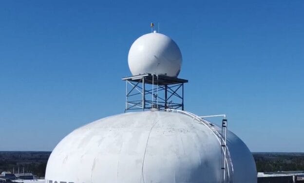
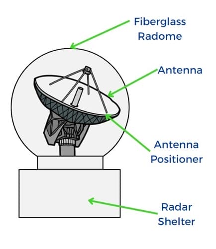
Weather radar serves as a fundamental observational tool within meteorology. Its physical appearance often resembles a large golf ball on a rotating dish or antenna tower. The primary purpose of weather radar is to emit pulses of electromagnetic waves into the atmosphere and observe their reflection as they interact with precipitation particles.
The core components of a weather radar system include a transmitter emitting these waves, a receiver to capture the reflected signals, and a sophisticated signal processor to analyze the data. This process enables meteorologists to determine the location, intensity, type, and movement of precipitation within the observed area.
How Do Weather Radar Systems Work?
At the heart of radar technology lies the principle of Radio Detection and Ranging (RADAR). These systems emit short pulses of electromagnetic waves into the atmosphere. As these waves encounter precipitation particles, they reflect back toward the radar unit.
By analyzing the time taken for the pulses to return and their strength upon arrival, the radar system calculates the distance to the precipitation, its type (rain, snow, hail, etc.), and its intensity. However, it’s important to note that while radar technology excels in detecting precipitation, it may encounter limitations in accurately capturing certain weather conditions like low level drizzle and differentiating between types of precipitation depending on many factors such as the band of radar and distance of the event from the radar.
Radar’s advantages include its ability to provide timely and essential data for forecasting and alerting about severe weather conditions. Nonetheless, drawbacks can exist, such as its range limitations and occasional false positives from non-precipitation reflections (such as aircraft, birds, insects, etc.), that require a high level of skill and scientific expertise to account for.
How Does Radar Help Predict the Weather?
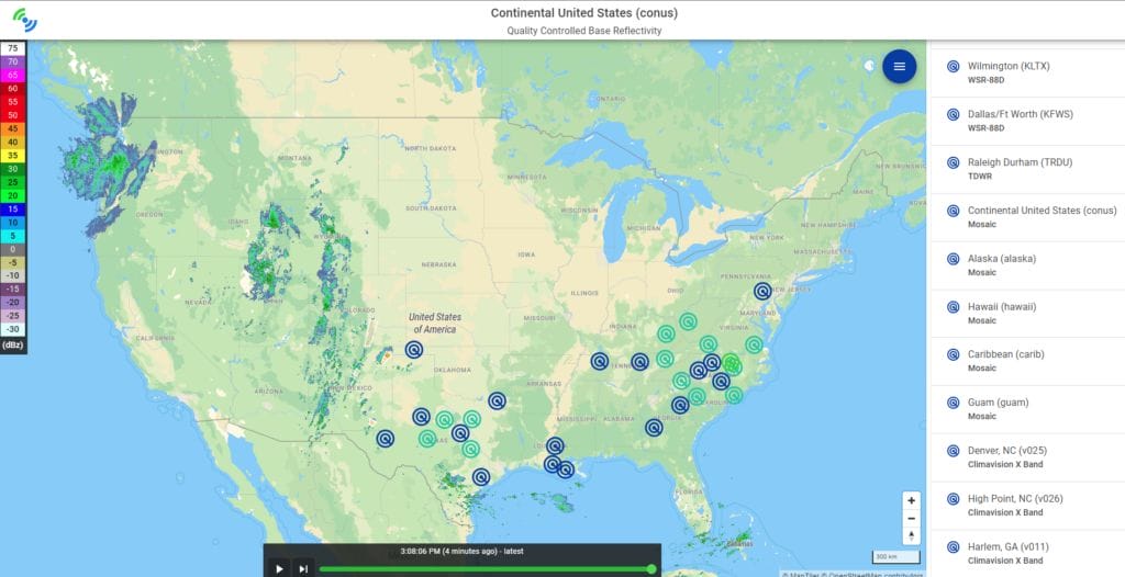
Radar data serves as a foundational element in the interpretation of weather patterns. Meteorologists convert radar data into visual representations, allowing for the mapping and analysis of precipitation patterns. These visualizations often incorporate color scales to denote the intensity of rainfall, enabling easier interpretation of precipitation levels.
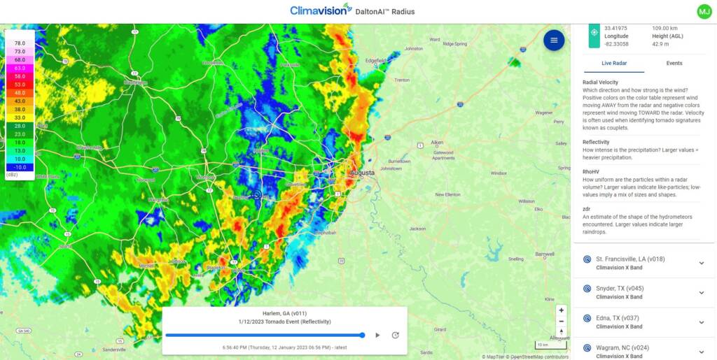
This radar-derived data forms a critical input for computer forecasting models. By providing information about the distance of precipitation, its speed, and droplet size, radar data significantly improves the accuracy of forecasting models. Importantly, radar technology proves highly effective in early detection and tracking of severe weather events before they occur as well as real-time insight into location, strength, and other factors as the event progresses.
Different radar bands and their respective networks contribute diverse datasets essential for precise weather predictions. These radar bands vary in their wavelengths, frequencies, and capabilities, providing complementary data that aids meteorologists in understanding and predicting weather phenomena more accurately.
Benefits of Radar Technology
Benefits:
- Monitoring and Tracking: Radar systems enable the continuous, real-time monitoring and tracking of weather patterns over extensive geographic areas.
- Precipitation Identification: Reliable identification and measurement of various forms of precipitation and wind events aiding in forecasting and preparedness for severe weather events.
- Timely Alerts: Prompt alerts for severe weather conditions enhance public safety and preparedness.
- Continuous Observation: Real-time observations allow for immediate response and adaptation to changing weather conditions.
- Enhanced Forecast Accuracy: Radar-derived data significantly contributes to the accuracy of weather forecasting models.
Limitations:
- Range Limitations: Due to the Earth’s curvature, optimal radar range typically spans between 3 to 125 miles, depending on the power output, (5 to 200 kilometers) causing low level radar data voids.
- Low-Altitude Precipitation: Inaccuracies might occur in detecting precipitation at low altitudes.
- Drizzle Detection: Challenges exist in accurately detecting low level drizzle due to its minimal reflectivity.
- Blind Spots: Radar systems encounter blind spots, known as the “cone of silence,” where scanning directly above is not possible.
- False Positives: Non-precipitation reflections like aircraft, birds, insects, and other objects may generate false positives in radar data interpretation and may require specific filtering algorithms.
Types of Weather Radar
Weather radar systems come in various types, each with unique features and functionalities. The doppler radar is the conventional type of radar and can be seen in several variations: Coherent pulsed (CP), Pulse-Doppler radar, Continuous wave (CW), or Frequency modulation (FM). These different doppler radar types offer varying advantages and are deployed based on specific operational needs. Pulse radars, for instance, are commonly used for their simplicity and cost-effectiveness. Pulse-Doppler radars remain the technology of choice for real-time, terrestrial weather observations.
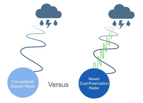
Because of its popularity and useful application, Doppler Radar has benefited from frequent technological updates. In more advanced, modern applications, Dual-Polarization technology is used. Legacy Doppler radar capability transmits and receives only horizontally polarized radio wave pulses. Single polarity systems only measure the horizontal dimension of cloud and precipitation particles. Modern dual-pol capability transmits and receives both horizontally and vertically polarized radio wave pulses. As a result, the returning frequencies provide measurements of the horizontal and vertical dimensions of targets, supplying forecasters with better estimates of the size, shape, and variety of targets. This is essentially the equivalent of looking at weather in 4-D.
Types of Weather Radar Bands
Distinguishing between different weather radar bands is crucial as each operates within specific wavelength and frequency ranges, offering distinct advantages and limitations.
What Is S-Band Radar?
With a frequency range of 2 to 4 gigahertz (GHz), S-Band radar is the largest, most powerful system designed to punch through large storms and scan for the longest range. The S Band offers moderate resolution suitable for various meteorological applications. The United States’ Next Generation Weather Radar (NEXRAD) network is made of S-Band radars.
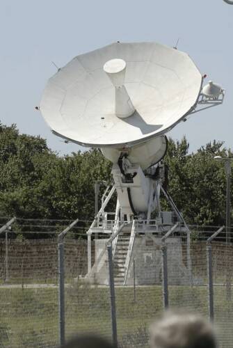
Its advantages include penetration through precipitation, making it effective for long-range observations. However, S-Band radar might face limitations in detecting smaller particles and because of its high power, cannot scan to the ground level. Additionally, since it is the largest system, the S-Band requires a lot of expensive ancillary equipment and can be costly to maintain and operate.
What Is C-Band Radar?
Operating within the frequency range of 4 to 8 gigahertz (GHz), C-band radar is used for many satellite communications transmissions, some Wi-Fi devices, some cordless telephones, as well as some weather radar systems.
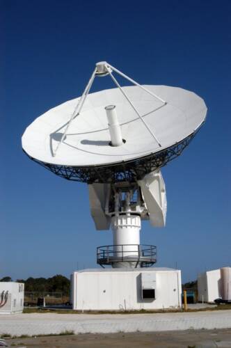
The C-Band radar’s capabilities strive to be a balanced option to the S- and X-band systems. However, challenges arise concerning heavy rainfall attenuation, susceptibility to interference from other sources (especially terrestrial microwave links), and its performance might be affected by specific atmospheric conditions.
What Is X-Band Radar?
X-band is often used in many types of modern radars and has a variety of systems that fall within its category with a range of different capabilities and advantages. Generally speaking, X-Band weather radar operates within smaller wavelengths, making it more sensitive and capable of detecting and identifying precipitation particles. This sensitivity allows for detailed short-range weather observation, making it especially useful for identifying precipitation that might otherwise go unnoticed by other radar bands.
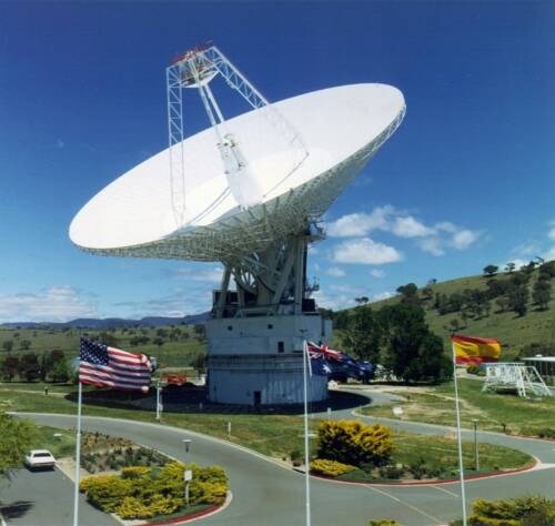
However, the smaller wavelength can sometimes challenge X-Band radar systems’ ability to penetrate heavy precipitation, which can obstruct its vision beyond the initial band of heavy weather. This limitation can be mitigated by utilizing more advanced algorithms or by incorporating a network of X-Band radars.
NEXRAD – The USA’s Public Weather Radar Network
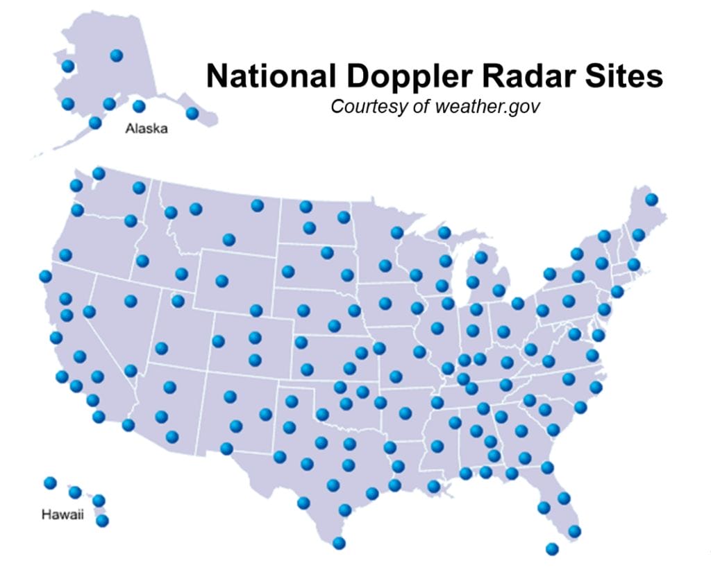
The Next Generation Weather Radar (NEXRAD), operated by the National Weather Service (NWS) in the United States, represents a sophisticated radar network designed for monitoring and forecasting weather patterns across the country. NEXRAD consists of a network of weather radars strategically positioned throughout the United States and its territories. NEXRAD radars are Doppler radar systems that utilize cutting-edge technology to provide critical weather data. They operate by emitting pulses of electromagnetic waves and analyzing the reflected signals to detect precipitation, track storms, and measure wind velocities within their coverage area.
Low Level Coverage Limitations
Despite its advancements and contributions to weather forecasting, the NEXRAD network faces certain limitations, primarily concerning low level coverage voids. These gaps occur due to the positioning and spacing of radar sites, leading to areas with reduced or limited radar coverage. Large swaths of the lower atmosphere (under 4,600 ft) remain unobserved as the earth curves away from the lowest beam of the nearest government radar or due to mountains or other blockages.
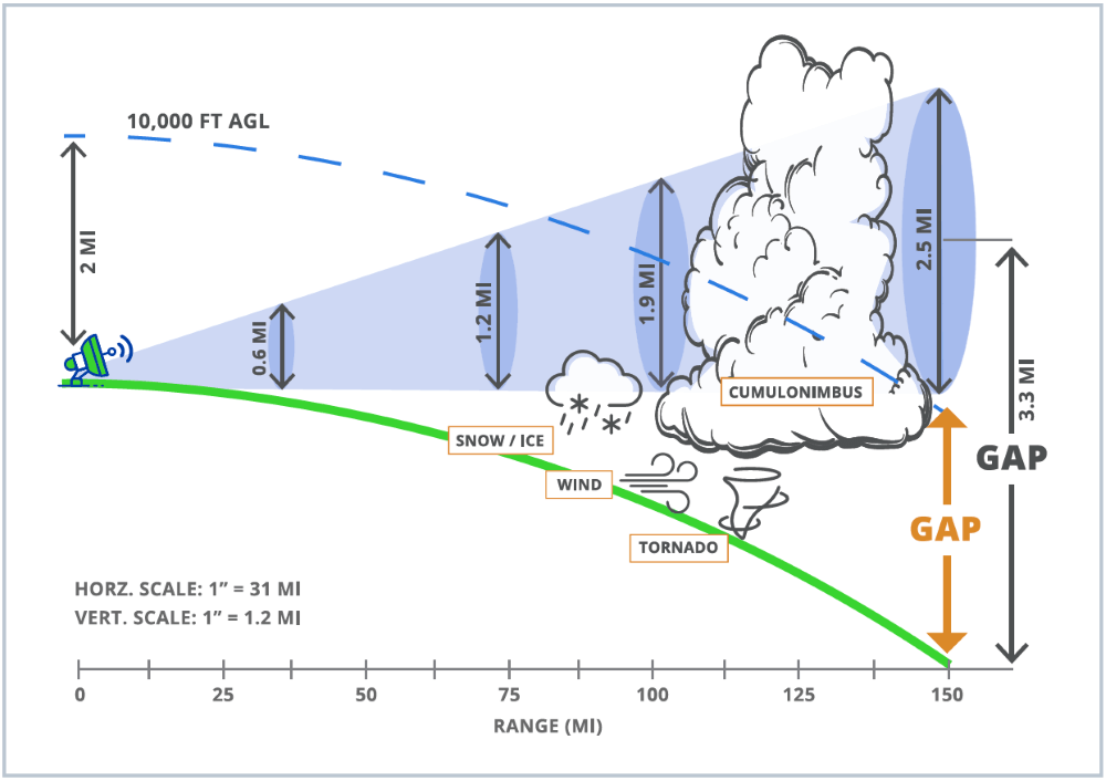
The number of weather-related disasters has increased by 500% between 1970 and 2019 (World Meteorological Organization). With the increased frequency and severity of weather events, voids in weather coverage can be severe. Filling in these spots is critical for flash flood warnings, low level mesocyclone observations, and improved forecast modeling which depend on measurements near the surface. Diminished radar coverage leaves surrounding residential and commercial areas vulnerable to sudden weather events and results in less accurate forecasts.
Low Level Radar Coverage Void Consequences
The NEXRAD network remains a cornerstone of weather monitoring and forecasting in the United States, but efforts to address and rectify its low level coverage voids are essential for ensuring the network’s effectiveness in safeguarding lives and property from the impacts of severe weather events. Some specific consequences include:
- Reduced Forecast Accuracy: Areas lacking adequate radar coverage may experience reduced forecast accuracy. Meteorologists might struggle to accurately predict weather events in these regions due to insufficient data.
- Delayed Warnings: In areas with coverage voids, warnings and alerts for severe weather conditions may be delayed or less accurate. This delay can impact public safety and preparedness, increasing the risk of damage or harm from unexpected weather events.
- Impacts on Weather Prediction Models: Incomplete data from coverage voids can affect the overall quality of weather prediction models. These models heavily rely on comprehensive and accurate data, and gaps in radar coverage may result in less reliable forecasts.
- Challenges for Emergency Response: Inadequate radar coverage could pose challenges for emergency response teams, as they might not have access to timely and accurate weather information in certain areas, potentially affecting their ability to respond effectively during severe weather incidents.
Addressing these coverage gaps in the NEXRAD network is crucial for enhancing the accuracy and effectiveness of weather forecasting and emergency response efforts across the United States.
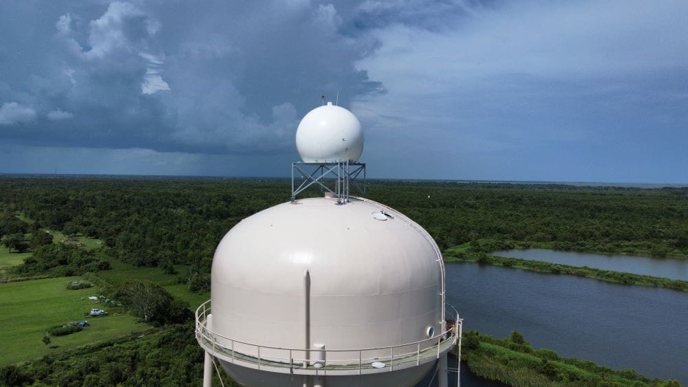
Efforts are ongoing to mitigate these low level voids by considering radar upgrades, additions, alternative technologies, or partnership with the private sector. Innovative solutions and advancements in radar technology aim to improve coverage and fill these voids to ensure more comprehensive and accurate weather monitoring and forecasting capabilities.
What Does It Take To Keep a Radar Network Running?
Maintaining and operating a radar network presents substantial challenges and costs. Attempts at both expanding the existing public NEXRAD network and establishing new proprietary networks often face difficulties in sustaining operational efficiency and reliability due to these factors.
The challenges begin at the start of installation. Every radar installation is a singular construction project – there are no “cookie cutter” installations. Every system must be accessible remotely and physically and must include its own power source, communications source, and redundant power source. Not only do these installation considerations require substantial funding, but they also require extensive knowledge and expertise of engineering and radar science.
Once installed, a reliable radar network must operate 24 hours a day, 7 days a week, 365 days a year. However, weather radars are NOT set it and forget it operations. It takes a team of radar scientists, program managers, engineers, and technologists observing the radar systems around the clock for data quality checks. Beyond the human requirement, there are a number of automated alerts constantly reporting details such as temperature, voltage, data flow analytics and more.
Like a car needs a check-up, every site needs a regular check-up and calibration and a field team available to respond to planned and unplanned maintenance at a moment’s notice. Weather radar parts are expensive and have long lead times due to their novelty. Unless parts are pre-purchased and on-hand, these parts can take up to 9 months to arrive.
These challenges highlight the necessity for established private partners, like Climavision, to help take on the burden of infrastructure and offer innovative solutions to industries such as governments for more accurate, reliable weather forecasting solutions.
Reliable Weather Radar With Climavision
Climavision revolutionizes weather forecasting by offering unparalleled accuracy and insights due in part to its terrestrial-based network of weather radars. This first of its kind weather radar network, which uses cutting-edge technology, helps overcome the challenges of traditional radar networks, providing better and faster weather forecasting solutions.
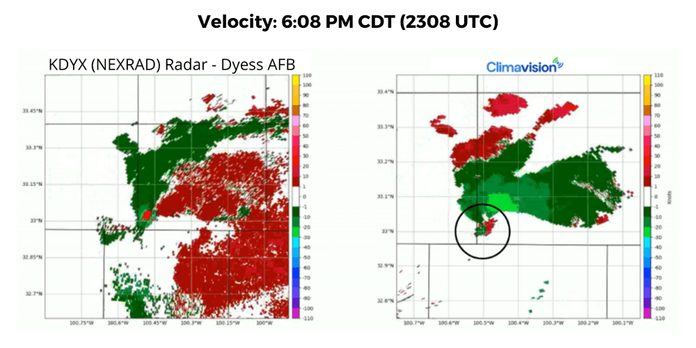
A Stonewall County tornado was indicated by storm chasers and locals on social media on June 17th, according to the Storm Prediction Center. The first signs of a tornado were detected by Climavision’s Snyder radar (right picture) at 6:02 pm CDT (2302 UTC). The nearest NEXRAD radar, KDYX, is pictured to the left. The National Weather Service did not issue a tornado warning until 6:23pm CDT (2323 UTC).
The Climavision network utilizes high-resolution, dual polarization radars to close significant weather observation data voids and drastically improve forecast speed and accuracy. Over the next 4 years, Climavision is rolling out over 200 radars across the continental United States. So far, more than two dozen radars have been installed.
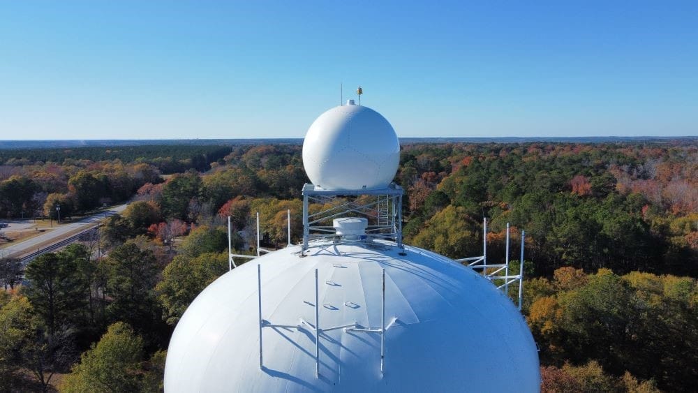
The goal of this innovative network is to arm federal agencies, local Emergency Managers, and weather sensitive businesses with the radar data they need to properly keep communities, employees, and assets safe and to gain a better understanding of the changing climate for more accurate forecasting.
Taking X-band to a New Level
As mentioned before, there are many flavors of X-Band radar, and each flavor has pros and cons. Climavision takes X-band radar to a new level with extensive radar expertise and the latest algorithmic advancements in weather science and technology.
Powerful Weather Detection
While X-band systems can be impacted by short moments of attenuation during strong convective weather due to their shorter wavelength, Climavision’s proprietary system integrates the latest scientific algorithms to help account for this challenge. Our network has already proven valuable in several weather scenarios including severe storms, wind events, snowstorms, and even during fires.
High Resolution is Key
One of the best benefits of Climavision’s dual-polarization, X-band systems is the detection and visualization of weather phenomena at ten times the resolution of larger, S-Band systems. High-resolution is especially important to see and understand what is happening closer to the ground where atmospheric conditions can become more volatile. Our radars are designed to focus primarily on these levels and to return a crisp, detailed picture of what is happening in near real-time. Climavision’s X-band system is so sensitive that clients can see phenomena that are not typically visible on a weather radar such as smoke and light snow. This means users can also better, and more accurately measure precipitation rates.
Designed to Fill Critical Coverage Voids
There are many types of small scale, highly localized, X-band radars available on the commercial market that help industries such as the marine, drone, and aviation sectors navigate challenging weather directly nearby. Climavision’s radars, however, utilize a much larger formatted X-Band system designed to fill large geographical coverage gaps more comprehensively and strategically between NEXRAD systems. Climavision systems are configured and optimized to cover a 60-mile radius. They not only cover their local “home” area but extend much further to “meet” the nearest NEXRAD’s scan and provide full coverage.
Sustainable Design
Many radars use large transmitters, such as a magnetron, but Climavision’s proprietary system uses a solid-state transmitter. A solid-state transmitter is a sustainable, stable, redundant type of transmitter, which consumes less power than a more standard form of transmitter. In other words, like an LED light is a more sustainable option than a standard incandescent light bulb, Climavision’s design offers a more sustainable option than legacy radar designs.
More Eyes in the Sky
At Climavision, we don’t compete with any type of radar and believe more eyes on the sky is a good thing. That’s why Climavision’s system is built not to replace, but rather to work in tandem with the NEXRAD network and provide a supplement to cover areas without weather radar coverage. We see immediate results every time we turn on a new radar in a coverage gap. Combined, both the public NEXRAD and Climavision’s proprietary systems paint the complete weather picture. The supplement systems have the added benefit of being a back-up system when NEXRAD systems go down for maintenance.
Improved Coverage Where It’s Needed Most
With the Climavision network of radars completely deployed, Radar Scientists at Climavision estimate that the percentage of detected tornadoes will double from 30 to 60% of tornadoes. Additionally, we calculated related injuries and fatalities for tornado events and estimate 30% of the fatalities occurred in low level radar coverage voids that Climavision is working to fill. Similarly, for high winds, Climavision radars will increase detection from 34 – 62%. Estimates and coverage of other weather phenomena will also be improved including hail size estimates, hurricane precipitation, and rain and snowfall rates and accumulations.
No Need for Expensive Radar Infrastructure
One major concern for those in need of a radar can be the cost. Most communities do not have the resources required to obtain a radar for themselves. The radars that comprise the NEXRAD network are very large, very expensive S-band radars. Not only do they require millions of dollars to initially install, but they also require a dedicated National Weather Service office and substantial funding per year to maintain.
Climavision radars simply supply weather data more efficiently. We offer access to this network as a simple subscription service called Radar as a Service, or RaaS. The major benefit of RaaS is that communities and clients can have this crucial weather data through a low annual data services contract instead of burdening communities with the hassle of a multi-million-dollar radar acquisition and continued operation.
Insights At Your Finger Tips
Advanced data visualization techniques and user-friendly interfaces make real-time weather data more accessible and understandable to the public while facilitating informed decision-making. The data from RAAS can be supplied to organizations in whatever way suits them best.
DOCK: The DOCK functions as a secure connection point for Climavision’s vast data lake. Allowing for deeper, more customized integrations to support business critical operations and time-sensitive workloads. Our APIs help you make informed decisions and derive insights while presenting visualizations through seamless integrations with your existing platforms.
RADIUS: Radius is a next generation, cloud optimized radar product viewing application that allows clients, partners, and Emergency Managers to view data from multiple radars in near real-time. Users can be informed as the action is happening through high-resolution Climavision X-Band radars and can also view data from the NEXRAD network.
Weather Radar FAQs
What is the purpose of weather radar?
Weather radar serves the purpose of detecting and monitoring weather events such as rain, snow, hail, damaging winds, and tornadoes, aiding in real-time weather monitoring and warnings, weather forecasting and providing crucial data for meteorologists to analyze and predict weather patterns.
What are the components of a weather radar?
A weather radar system comprises a transmitter emitting electromagnetic waves, a receiver capturing reflected signals, and a signal processor analyzing the data to determine precipitation characteristics.
Is weather radar accurate?
Weather radar is one of the most successful observing systems for scanning the skies and monitoring for rain, snow, hail, damaging winds, and tornadoes. Weather radar monitors for these weather events by providing information on precipitation type, intensity, and movement.
What do weather radar colors mean?
Colors on weather radar reflectivity visualizations, the radar product most commonly viewed on apps or television, usually represent different intensities of precipitation. Greens may indicate light or moderate rainfall while yellow, orange, and red indicate heavier rainfall or hail. Whites or blues can mean snowfall and pink usually indicates freezing rain, sleet, or a wintry mix. Other weather events like high wind and tornadoes are monitored with velocity and have associated colors, such as red and green.
How does radar track a storm?
Radar tracks storms by emitting pulses of electromagnetic waves, analyzing their reflection off precipitation particles, and measuring their distance, intensity, and motion.


