
Advanced Weather Data for Government Agencies
EMPOWERING BETTER DECISIONS
AND PLANNING
We’re a private sector resource partnering with government agencies to assist in the protection of communities, commerce and national security through the production and delivery of advanced meteorological intelligence.
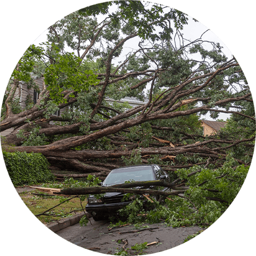
Be Better Prepared Before and After The Disaster
Climavision offers advanced solutions to address the rise in extreme weather events. Our technology assists government agencies, public safety, and emergency management teams in preparing for and responding to natural disasters.
Before and during extreme weather, we provide real-time supplemental weather radar data for decision-making, improving preparedness and response efforts. Following disasters, our solutions offer quick access to weather impacts to aid responders in formulating effective strategies.
By integrating our weather data with GIS systems, planners can proactively mitigate risks. With Climavision, communities can better prepare for and respond to the challenges of an evolving climate.
Our Government Solutions
Help You Prepare
Across the many applications of Government, we have solutions customized to meet the specific application needs.
- Federal Government
- State Government
- Local Government
Federal Government
The emerging landscape of weather extremes presents a formidable challenge for federal agencies tasked with safeguarding communities against climate volatility. In situations where lives hang in the balance, access to the most precise and dependable weather data becomes paramount. Our supplemental radar network and next-generation forecasting solutions are designed to empower federal agencies—including the Department of Defense and Homeland Security—in developing robust emergency responses and strategic plans to address the escalating threats posed by more frequent extreme weather events. By leveraging our advanced technology, agencies can mitigate risks, enhance preparedness, and effectively manage the actual costs associated with weather-related crises.

State Government
We recognize the delicate balance between adhering to federal safety mandates and addressing the distinctive requirements of municipalities. That's why we're dedicated to providing next-generation radar coverage, empowering you to make informed and defensible decisions. Through our advanced supplemental radar network, we harness high-resolution radar data to assist state agencies in implementing and upholding policies that bolster resilience against the growing threat of frequent and severe weather events. Our real-time, low-altitude observations, facilitated by proprietary sensors, offer unparalleled precision, mitigating risks and enhancing preparedness at every step.

Local Government
Our supplemental radar data equips local government leaders with actionable weather insights, empowering them to make decisions that enhance safety and foster economic resilience. Leveraging our network of high-resolution radars, we effectively minimize the risk to communities posed by swiftly evolving weather patterns by bridging the gaps in existing technology through overlapping scanning. Through high-definition visualizations of fast-moving storm systems, we enable the identification and prioritization of hard-hit areas within communities, facilitating targeted response efforts. Furthermore, by integrating Climavision's proprietary weather data with GIS systems, planners can develop land-use policies aimed at improving safety and proactively mitigating risks.


SOLUTION: RADAR AS A SERVICE
RaaS Changes Everything
Climavision is installing a high-resolution radar network to supplement the existing National Weather Service NEXRAD network across the nation, siting them in locations that need them the most. Owned and operated by Climavision, the privately-owned network will deliver commercial, best-in-class Radar-As-A-Service (RaaS) products to government agencies at all levels.
Benefits of RaaS
- Mobile friendly, browser based real-time display of local radar products such as reflectivity, velocity to show you rain, snow, hail, and tornadoes
- Immediate access to archived storm data such as hail and tornado signatures and rainfall accumulation to assist in disaster response activities such as dispatch and recovery, forensic analysis, and long-term storm data to support report and proposal writing.
- Low annual data services contract instead of burdening communities with the hassle of a multi-million-dollar radar acquisition
Arming the National Weather Service with Supplemental Radar Data
Since May 2022 Climavision has participated in a Cooperative Research and Development Agreement (CRADA) with NOAA’s National Severe Storms Laboratory (NSSL) by providing real-time polarimetric radar data for testing and integration into the Multi-Radar Multi-Sensor (MRMS) operational product suite.
Additionally, since September 2023, the National Weather Service (NWS) has been procuring radar data from Climavision under the National Mesonet Program. This partnership involves the delivery of live radar data from thirteen Climavision radars for the internal use of NOAA scientists and operational forecasters across 21 Warning Forecast Offices, 4 NWS Regional Headquarters, the Radar Operations Center, and the Storm Prediction Center.

Confidently Protect Lives and communities
with Advanced Weather Technology

LEARN MORE ABOUT WEATHER RADARS
What is a Weather Radar? Your Guide to How Radar Works
Weather radar stands as an indispensable tool within meteorology, serving as a pivotal instrument for observing severe weather events and predicting weather patterns. This guide aims to provide a comprehensive understanding of weather radar systems, their functionality, various radar bands, strengths, weaknesses, and their significant role in weather forecasting.
WE’RE REVOLUTIONIZING THE WEATHER INDUSTRY
Our extensive weather data and revolutionary, AI-driven climate technologies identify real-time dangers and produce more accurate predictions and forecasting models.
Learn More About What Makes Us Different
Radar Network
First of its kind, supplemental nationwide, high-resolution, dual polarity radar network
Advanced Modeling
Advanced global numeric weather prediction modelling with unprecedented computational capabilities
Observational Datasets
More unique and novel observational datasets assimilated via AI for faster, more accurate forecasts
Technical Expertise
Unparalleled technical expertise across infrastructure, machine learning, cloud and supercomputing
“Over the last five years, weather-related deaths are up 35% from 2017“
NCS Injury Facts
BLOG
Want to learn more? Read our latest blog posts


