Summer 2023 Weather Events in Review
The summer of 2023 has been one for the record books. As the end of meteorological summer arrives, locations across the globe continue to experience unprecedented weather events. From June to August a wide range of weather events occurred, ranging from major disasters leading the nightly news headlines to undetected events showcasing the need for Climavision’s supplemental data. These severe weather situations and their impacts only continue to emphasize the need for fast and precise weather insights.
June Highlighted the Need for More Low Level Radar Coverage
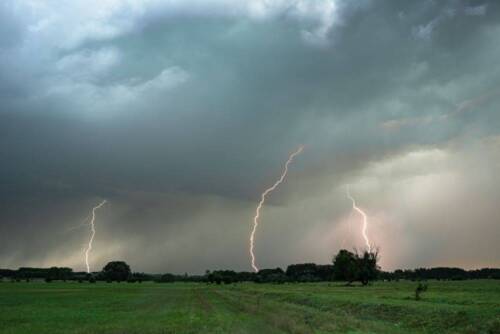
The first half of 2023 ended with a series of tornadic events, highlighting the need for better weather radar coverage. Within a one-week period spanning from June 11th to June 17th, 2 tornadic events occurred near Climavision radar sites that were either unwarned or warned well after Climavision’s initial detection. Unwarned, or late-warned tornadic events have severe implications for communities and businesses. Assets, operation, and most importantly, people are all at stake.
The heightened tornadic activity is not surprising for the first month of summer. June is typically one of the most active months of the year for tornadoes related to both severe weather outbreaks and tropical weather. However, you may be surprised to learn tornadoes can sometimes go undetected by government radars. This is due to low-level radar coverage voids caused by the curvature of the earth.
Crossville, TN Tornado – June 11, 2023
WATE-TV viewers spotted a tornado in Crossville, Tennessee that was unwarned because it went undetected by the nearest NEXRAD radars. The NWS declared it an EF1 tornado with 95 mph winds following post-storm analysis. Thankfully, no one was injured by this tornado. However, this instance clearly highlights the need for supplemental low-level radar data between existing NWS sites, increasing the detectability of dangerous events.

Stonewall County, TX Tornado – June 17, 2023
A Stonewall County tornado was indicated by storm chasers and locals on social media on June 17th, according to the Storm Prediction Center. The first signs of a tornado were detected by Climavision’s Snyder radar at 6:02 pm CDT (2302 UTC). The National Weather Service did not issue a tornado warning until 6:23pm CDT (2323 UTC). Using the Climavision radars in conjunction with the NEXRAD radar network has the potential to significantly improve tornado detection and lead to earlier warning times to protect life and property.

For more insight into these events, read our blog post June 2023 Tornadic Events Highlight Need for More Low Level Radar Coverage.
July Was The Busiest Month In The US For Severe Weather
July was an incredibly active month for severe weather across the United States. In fact, it was the most active July for Severe Thunderstorm activity on record for the US (Washington Post). Multiple large-scale thunderstorm outbreaks occurred during the month and produced the most reports of severe weather in the United States on record for July.
Here are the July Stats for 2023, as reported by the Washington Post:
- Together June and July yielded 528 reports of hail larger than two inches in diameter across the United States. The previous record for an entire summer, defined as June, July and August, was 378 reports in 2009. For July alone there were 188 reports of hail two inches or more in diameter, which is also a record.
- There were exactly 150 tornado and severe thunderstorm watches issued, the most July watches since 2003.
- The Storm Prediction Center determined at least a level 2 out of 5 “slight” risk of severe weather every day.
- There was a July record of 6,637 severe weather reports, meaning thunderstorm wind damage, gusts over 58 mph, quarter-size hail or tornadoes occurred. The previous record holder was July 2016, which netted 5,642 reports.
Specifically, North Carolina Severe Weather Activity Was High
North Carolina in particular, where Climavision now has three supplemental radars, experienced significant weather events from damaging winds to a tornado. Damaging winds were reported to the Storm Prediction Center 21 days of the month.
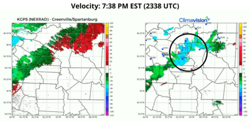
One of those days reported was July 29th, when the Charlotte metro area was under a Severe Thunderstorm Watch. Charlotte, NC has been a well-known low-level radar gap for many years. Now, Climavision’s radar in Denver, NC provides the critical coverage for the large community’s needs.
The nearest NEXRAD radar to Charlotte is KGSP- Greenville/Spartanburg in South Carolina. The radar beam from the KGSP site in Greer sits at 7,000+ ft AGL (above ground level) over Charlotte, while the beam from Climavision’s radar in Denver, NC sits at approx. 1,300 ft AGL.
In the example below, a line of thunderstorms was moving in a southeastern direction towards the Charlotte Metro area. On the right side is our Climavision radar. In the reflectivity image, notice the definition and high-resolution of the storm imagery. It is easy to indicate where the heavier bouts of rain are located.

In the next set of images, Climavision’s resolution is superior in velocity, as well. The data from Climavision’s radar indicated storm velocities of near 60 mph. It is important to note that Severe Thunderstorm threshold winds are at 58 mph or greater. Using the KGSP data alone, it would be difficult for forecasters to precisely determine the strength of the thunderstorm, and the potential danger it posed to the local population.
Low-level data-void filling radar data is essential not just when tornadoes strike, but in moments like the line of thunderstorms shown below to differentiate between a run-of-the-mill thunderstorm, and a severe thunderstorm with damaging winds to where citizens should be advised to seek shelter.
Europe Faced a Range of Extreme Weather
The Summer of 2023 has been marked by a series of severe weather events that are examples of the new norms we can expect of extreme weather. This means that unfortunately these events are not isolated incidents; they are the manifestation of a changing atmosphere and are expected to become more frequent and severe in the coming years.
These storms came after a record-hot air mass that languished over Europe much of the previous week. Sardinia, Italy, soared to 118.4 degrees Fahrenheit on July 17th, provisionally tying the record for hottest temperature observed in Europe during the month of July. The hot, humid air contained extreme instability, or fuel, to foster the development of strong to severe thunderstorms. (The Washington Post)
The severe weather across Europe had deadly impacts – several people were injured or died across Italy, Croatia, Slovenia, and Serbia. You can read more about these severe weather events in our blog post From Heatwaves to Hailstorms, Europe’s July of 2023 Was Destructive.

Milan experienced hail, rain, and strong winds on July 24. From the Washington Post
Lahaina Wildfire Took The Community By Surprise
A catastrophic fire that swept through the town of Lahaina, Hawaii, last week is now being called the deadliest wildfire in modern U.S. history. (Fox Weather) On Maui, an island of Hawaii, the Upcountry fire started first, reported not long after midnight on Tuesday, and the first evacuations near Kula followed. The fire near Lahaina started later, around 6:37 a.m. Tuesday. By the end of the day the town was covered in either flames or smoke. (ABC News)
Much of Hawaii was under a red flag warning for fire risk when the wildfires broke out, but the exact cause of the blaze is still unknown. Multiple dangerous weather factors came into play to fuel this fire. First, Maui has been in a drought. Having dry conditions for that long of a time was the reason the National Weather Service issued the red flags – trees and other debris that stay dry for long periods of time are the perfect fuel for wildfires. There were also high winds to contend with. The powerful winds fanning the flames were generated by Hurricane Dora, a storm that was moving across the Pacific Ocean hundreds of miles south of the Hawaiian Islands. (CBS News)
The fire in Lahaina is the deadliest American wildfire in more than 100 years, with more than 5,000 structures being damaged or destroyed. In a Facebook post, officials said that of the affected buildings, nearly 90% have been reported as residential structures. (Fox Weather)

An aerial view of fire damage in Lahaina on Aug. 11, 2023. Hawaii Department of Land and Natural Resources
Tropical Storm Hillary Hit Southern California
Hilary was the first tropical storm to hit Southern California in 84 years. Hilary strengthened to a Category 4 hurricane before weakening to a tropical storm prior to making landfall on Sunday August 20th. By early Monday morning the storm was downgraded to a post-tropical storm. (CBS)
17 million Americans were under flood and high-wind advisories, watches and warnings as the storm occurred, dumping heavy rains from the California-Mexico border up through Las Vegas and into parts of the Northwest. (Reuters)
The National Weather Service’s Los Angeles office said on social media that “virtually all rainfall daily records” for the area were broken as of 3 a.m. PDT Monday, August 21st. Flooding impacted many areas and numerous rock and mudslides were reported. Additionally, tens of thousands of people across Southern California had no power due to the storm and Palm Springs lost 911 service the night of Sunday August 20th. (CBS)

Pictured above the total rain accumulation forecasted on August 18th by Climavision’s GRO model.
What Does this Mean for Businesses?
The summer of 2023 highlights that the world is experiencing a new norm of extreme weather. Volatile, dangerous weather is to be expected now. The increased frequency or strength or even both in weather events have severe implications for businesses and communities. Organizations across different sectors and industries will be impacted and have to contend with more risk. The energy industry will contend with volatile pricing as unexpected extreme heat and cold test supply with increased demand. Agricultural operations are at risk of losing products instantly from an extreme storm, or wildfire event. Outdoor events rely on clear skies to operate and if they don’t, peoples’ safety, and even lives, can be at risk. Retailers are impacted by severe weather as they can lose demand, inventory and even infrastructure if an extreme event destroys brick and mortar locations. The entire supply chain can be impacted when the transportation industry is affected by dangerous conditions on the roads or in the sky.
What Tools Reduce Weather Related Risk?
The severe weather events experienced so far this summer across the world serve as stark reminders of the need to prioritize extreme weather insights. By leveraging accurate weather data and forecasting, organizations can bolster resilience and safeguard communities. Advancements in technology will become crucial for increasing the speed and accuracy of weather insights. Better radar coverage, expanded unique observational datasets, cutting-edge numerical weather prediction models, and the integration of Artificial Intelligence offer tremendous potential for improving weather forecast accuracy. With Climavision’s investment and innovation in these areas, communities and businesses can strengthen their preparedness, save lives, and minimize risk caused by extreme weather events. If you like to learn more, contact us.


