June 2023 Tornadic Events Highlight Need for More Low Level Radar Coverage
The first half of 2023 ended with a series of tornadic events, highlighting the need for better weather radar coverage. Within a one-week period spanning June 11th to June 17th, two tornadoes occurred near Climavision radar sites that were either unwarned or warned well after RaaS’s (Radar as a Service) initial detection. Unwarned, or late-warned tornadoes have severe implications for communities and businesses where assets, operations, and most importantly, lives are all at stake.
Heightened tornadic activity is not unusual for the first month of summer. June is typically one of the most active months of the year for tornadoes related to both severe weather outbreaks and tropical weather.
Our National Weather Service does an exemplary job of warning citizens of impending dangers due to severe weather. However, issues can arise in areas not well covered by government radars and sometimes tornadoes go undetected for a very simple reason. Due to the curvature of the earth, if a radar is 60 or more miles away from the tornado, the radar beams can “overshoot” or pass above the top of the storm. Overshooting of the beam creates low level radar data void coverage areas.
Crossville, Tennessee – June 11th, 2023:
Crossville, Tennessee is a data void areas for NWS radars, sitting approximately 75 miles from the KOHX radar near Nashville and 85 miles from KMRX near Knoxville. Climavision’s radars have been installed to fill in these data voids and this proved beneficial to Crossville. Climavision’s lowest radar sweep is approximately 1,450 ft above ground level, compared to the 6,200 ft and 7500 ft heights of the KOHX and KMRX radar sweeps, respectively. 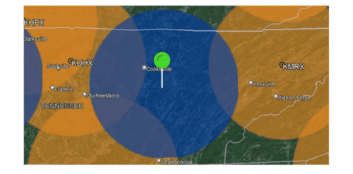 Climavision Crossville, TN Radar coverage in Blue with surrounding NEXRAD Radar coverage in Orange
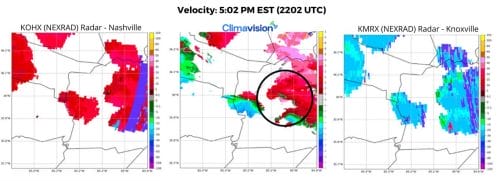
On June 11th, 2023, WATE-TV viewers spotted a tornado in Crossville, Tennessee. This tornado was unwarned because the main structure of the storm was well below the beam of the NEXRAD radars. (WATE) The National Weather Service declared it an EF1 tornado with 95 mph winds following post-storm analysis view the storm report here. This is a prime example of radar void-filling coverage at work. Climavision’s radar located in Sparta, TN picked up on rotation from the storm. In the below velocity and storm reflectivity it is clear to see 1) the high-quality resolution of the Climavision radar in Sparta and 2) rotation on the western edge of the storm cell.

Thankfully, no injuries were reported with this unwarned storm. Having a clear view of the storm is essential in the ability to issue timely warnings.
Stonewall County, Texas – June 17th, 2023:
On June 17th, 2023, storm chasers and locals took to social media to document a tornado near Red Bluff Crossing in Stonewall County, Texas (SPC). Climavision’s radar in Snyder is less than 40 miles from where the tornado was spotted, while Red Bluff Crossing sits about 70 miles from the nearest NEXRAD site, KDYX. This puts the Climavision Synder radar sweep over Stonewall County at approximately 1,500 ft above ground level, compared to the 5,600 ft height of the NEXRAD KDYX radar beam.

Climavision Stonewall County, TX Radar Coverage in Blue with Surrounding NEXRAD Radar coverage in Orange
The first signs of a tornado were detected by Climavision radar at 6:02pm CDT (2302 UTC). The National Weather Service (NWS)issued warning until 6:23pm CDT (2323 UTC) relying only on the NEXRAD radar. Using both the NEXRAD and Climavision radar networks in conjunction can significantly improve upon tornado detection and provide earlier warning times to help protect lives and property.

 It is important to note the high-resolution of the Climavision radar, which gives meteorologists the ability to clearly detect rotation, hail cores, and debris balls, as well as deciphering finer details.
Better Detection of Dangerous Weather is Critical
Dangerous weather events, like these two June tornadoes, make fast and accurate weather data crucial. At Climavision, we’re deploying a proprietary network of high-resolution weather radars to close significant data voids and provide more accurate low level coverage and better lead time on threats. Climavision has more than a dozen radars installed with plans to have 30 radars operational by the end of this year and eventually scaling the network to more than 200 radar systems across the continental United States.. Governments and businesses can access this network through our Radar-as-a-Service, or RaaS.
Radar Scientists at Climavision estimate that once deployed, our radar network, will double the percentage of radar-detected tornadoes from 30 to 60%.
Radar as a Service serves as a vital additional resource that helps protect lives and property. Contact us to learn how Climavision’s radar solutions may benefit your organization or community.


