Climavision Radar Network: Critical Summer Performance
Weather has a profound impact on organizations such as federal and state emergency management agencies, logistics companies, and the insurance industry. These sectors rely on real-time, accurate weather data to make critical decisions that can affect safety, efficiency, and financial risk management. From responding to severe storms to planning optimal logistics routes, reliable weather forecasting is essential.
Climavision plays a crucial role in supplementing the national weather radar system, addressing coverage gaps left by the NEXRAD network. In fact, the National Weather Service extended their contract to continue accessing data from 13 of Climavision’s radars across 7 states via the National Mesonet Program. Our network of high-resolution radars ensures that organizations of all types have access to the data they need, especially in underserved regions. This blog highlights gaps in weather radar coverage in the US, the value of Climavision’s supplemental radar, and showcases how our radars performed during key weather events in the summer of 2024.

In Summary:
- Current limitations: Gaps in coverage, especially in rural and underserved areas, leave organizations vulnerable to missed severe weather events.
- Climavision’s enhanced radar network: High-frequency, high-resolution radars fill in the blind spots.
- Key performance during summer 2024: Climavision’s radars captured critical weather events that went undetected or under-reported.
- Case study insights: Climavision radars provided superior data on wind speeds, tornado activity, and outflow boundaries, improving forecasting and decision-making.
- Take Action: Explore how Climavision’s radar network can enhance your weather data strategy by requesting a demo.
Climavision’s Supplemental Radar Network
The NEXRAD radar network, while robust, is not without its limitations. Due to the curvature of the earth and higher beam heights, gaps in NEXRAD coverage exist across the US where critical low-level weather events like severe winds or tornado signatures can go undetected. This especially impacts rural areas or regions with complex topography, leaving critical weather patterns undetected. As the demand for hyper-local and real-time data increases due to more frequent and severe weather events, these blind spots become more evident and problematic.
This is where supplemental radar becomes essential. Climavision’s network is designed to cover those blind spots, providing higher resolution data, closer to the ground, and more frequently, to ensure a clearer and more complete picture of rapidly developing weather conditions.
The technical advantages of Climavision’s radars include higher resolution reflectivity and velocity data, allowing us to detect smaller-scale phenomena, like outflow boundaries and low-level rotations, which can be missed by NEXRAD radars. By integrating Climavision’s network into existing weather systems, we enhance the precision and timeliness of weather data for organizations.
Data Delivered by Climavision’s Radar
Climavision’s radars provide crucial data on precipitation, wind patterns, storm tracking, and other weather metrics that help organizations make informed decisions. For industries such as aviation and insurance, this data is especially valuable. The ability to detect precise wind speeds, for example, can improve flight safety and optimize storm risk assessment for insurance claims.
In addition to more accurate detection of severe weather, the high-resolution data offered by Climavision allows organizations to better plan for safety and manage risks. Whether preparing for severe thunderstorms, tracking potential tornadoes, or responding to outflow boundaries, having detailed weather data at your fingertips is critical.

Case Studies from Summer 2024
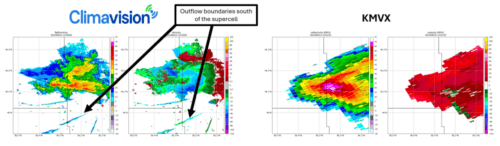
Case Study 1: Wilkin County, MN Supercell
Severe threshold winds brought damage to cornfields between Wilkin County and Grant County, Minnesota as a supercell impacted the location on the afternoon of June 12th. Quarter sized hail was also present. Climavision’s Grant County radar detected wind speeds of 60-65 mph, surpassing the Severe Thunderstorm criteria of wind speeds greater than or equal to 58 mph. The nearby KMVX NEXRAD was only able to indicate wind speeds of ~40 mph in the same location due to beam height.
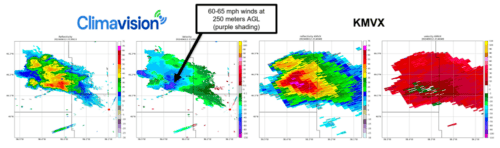
In addition to showcasing high resolution and accurate detection of wind speed with this severe event, Climavision’s Grant County also captured another phenomena: outflow boundaries. These bands are the difference between thunderstorm cooled air and the surrounding air mass. Outflow boundaries can come with a shift in wind direction and temperature drop. They are important for aviation as they pose risks for aircraft landing and taking off. They can also trigger the development of additional storm cells.
Case Study 2: Kentucky Severe Wind Speeds
Climavision radar in Dry Ridge, Kentucky sampled storms with severe wind speeds of 75 mph in Carroll and Owen counties. The damaging winds led to downed trees, power lines, and a metal roof partially being torn off a barn. The storms these high wind speeds were associated with went unwarned, likely due to NEXRAD beam-height.

Our Dry Ridge radar displays the most accurate detection of wind speeds within the velocity data, as well as the highest resolution reflectivity, allowing for the clearest understanding of the storms impacting the area.

Case Study 3: Harrisburg, PA Tornado
The remnants of Hurricane Debby swept up the East Coast in early August, eventually spinning off severe weather events in Pennsylvania. Climavision’s Lancaster County radar captured the detail of an unwarned EF-1 tornado that hit eastern Harrisburg in the early morning hours.
Climavision’s radar data was able to capture a clear velocity couplet. In the same location and at the same time stamp, RhoHV correlation coefficient data sampled a TDS, or Tornado Debris Signature as circled in yellow to the right.

In comparison with data from the KCCX NEXRAD radar in State College, Climavision’s radar is sampling a lower level of the atmosphere over Harrisburg. For this event, KCCX’s beam height is too high to capture the low-level rotation and debris signature, therefore the tornado event is not detectable in this radar imagery.

Case Study 4: Mid-MO Outflow Boundary
Several strong storms popped up around Climavision’s Boonville, MO radar on August 27th. The radar was able to clearly capture an outflow boundary coming off one of the cells. This is significant as outflow boundaries can impact aviation activity. Local ASOS stations identified wind speeds of 40 knots while Climavision detected winds in the range of 20-30 knots.
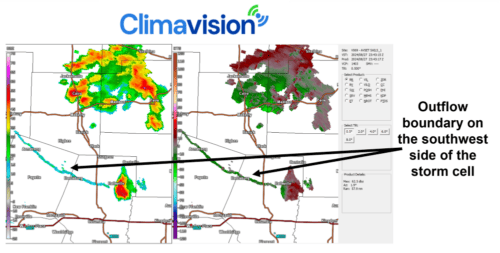
In comparison, neither KLSX or KEAX NEXRAD radars showed an outflow boundary in their data from the same timestamp.

High Resolution Radar at Your Fingertips
Supplemental radar coverage is critical to bridging the gaps in the NEXRAD network. Climavision’s radar network provides organizations with enhanced data that helps them respond to severe weather more effectively. From detecting supercell winds to identifying tornado debris signatures, Climavision’s radar offers a level of detail unmatched by the NEXRAD network alone. Want to see how Climavision’s radar network can improve your weather forecasting? Request a demo today and discover the power of high-resolution weather data for your business.