Weather Technology Tackling Atmospheric Convection
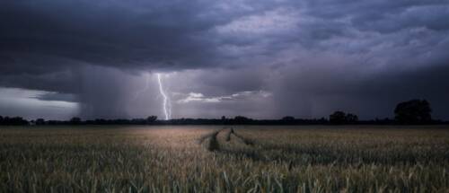
The atmosphere is constantly in motion, and one of the driving forces behind its changes is atmospheric convection. This process, where warm air rises and cooler air sinks, powers everything from gentle showers to destructive thunderstorms, hailstorms, and tornadoes. These weather phenomena pose significant risks to industries like energy trading, electric utilities and TV broadcasting, along with government agencies responsible for public safety and infrastructure resilience.
For sectors relying on weather stability, anticipating convective events is essential. From sudden market shifts in energy trading to power outages affecting grid stability, understanding and mitigating the impacts of severe weather is vital for business continuity and public safety.
In Summary
- Understanding Atmospheric Convection: This fundamental process drives severe weather events such as thunderstorms, hail, downbursts, and tornadoes, posing significant risks to industries like energy trading, electric utilities, TV broadcasting, and government agencies.
- Forecasting Challenges: Government radars and Numerical Weather Prediction (NWP) models face limitations, including poor low-level atmospheric coverage, resolution constraints, data assimilation gaps, and computational challenges, hindering accurate short-term weather forecasting.
- Climavision’s Radar-as-a-Service (RaaS): This solution fills critical radar coverage gaps with a network of 200+ X-band radars, providing hyper-local, real-time data to help government agencies, broadcasters, and utilities proactively manage severe weather risks.
- Horizon AI HIRES Forecasting: This high-resolution, hyper-local model delivers precise weather forecasts, allowing energy traders, utilities, and broadcasters to optimize operations, stabilize energy grids, and enhance emergency response strategies.
- Proven Real-World Results: Climavision’s technologies outperformed traditional models during major events like the 2024 Camden Tornado and 2024 Houston Derecho, proving their effectiveness in predicting severe weather with greater accuracy and reliability.
What is Atmospheric Convection?
Atmospheric convection is a fundamental process in the Earth’s atmosphere that drives the vertical movement of air. It occurs when the sun heats the Earth’s surface unevenly, causing the air above warmer areas to rise as it becomes less dense. Cooler, denser air then moves in to replace the rising air, creating a continuous vertical circulation.
Causes of Atmospheric Convection
- Uneven Heating: Solar radiation heats land and water at different rates, causing air temperature differences that initiate convection.
- Topography: Mountainous regions can force air upwards, triggering convection and leading to weather changes.
- Surface Characteristics: Variations in land cover (e.g., forests vs. urban areas) can enhance local temperature differences, promoting convection.
Results of Atmospheric Convection
Thunderstorms
One of the most recognizable outcomes of atmospheric convection is thunderstorms. The rising warm, moist air can lead to the formation of towering cumulonimbus clouds. These storms can bring heavy rain, lightning, and thunder, and under the right conditions, they may evolve into severe weather events, such as supercells, which can produce tornadoes.
Hail
Strong updrafts within thunderstorms can carry raindrops upward into extremely cold regions of the atmosphere. There, they freeze and accumulate layers of ice, forming hailstones. The size of hail can range from small pellets to golf ball-sized or larger, causing significant damage to property like solar panels.
Downbursts
When a thunderstorm collapses or dissipates, it releases a powerful downdraft of cool, dense air known as a downburst. These can create strong, damaging winds at the surface, causing localized destruction.
Tornadoes
Under certain conditions, atmospheric convection can give rise to tornadoes. The interaction between wind patterns, temperature, and moisture can result in the formation of rotating thunderstorms, or supercells, which may produce these violent and destructive funnels of air. Tornadoes can have devastating impacts on communities and infrastructure.

Challenges in Forecasting Convective Weather Events
While government radar networks, like NEXRAD, offer valuable long-range scanning capabilities, they often fall short in providing adequate low-level atmospheric coverage. This creates blind spots for detecting severe weather phenomena near the Earth’s surface, particularly in rural and mountainous regions.
Additionally, Numerical Weather Prediction (NWP) models face challenges in accurately simulating convective weather. Traditional models often struggle with:
- Resolution Limits: Many NWP models lack the spatial resolution needed to capture small-scale, localized weather events that can lead to sudden severe storms.
- Data Assimilation Gaps: Incomplete or inaccurate observational data can lead to poor initial conditions, reducing the accuracy of forecasts.
- Complex Physical Processes: Accurately modeling the physical processes behind convection, such as cloud formation, heat transfer, and turbulence, remains a significant challenge.
- Computational Constraints: High-resolution forecasts require significant computational resources, limiting how frequently updates can be generated.
These limitations hinder the ability to provide precise, short-term forecasts essential for industries that depend on accurate weather predictions, such as energy trading, utilities, broadcasting, and emergency management.
Climavision’s Solutions: Radar-as-a-Service (RaaS) and Horizon AI HIRES
To bridge these gaps, Climavision offers two cutting-edge solutions designed to enhance severe weather detection and forecasting:
Radar-as-a-Service (RaaS): Filling Critical Coverage Gaps
Climavision’s RaaS provides high-resolution, low-level radar coverage through an expanding network of over 200 X-band dual-polarization radars. This system dramatically improves near-surface weather detection, allowing:
- Government Agencies to access critical data for emergency preparedness and early warning systems.
- TV Broadcasters to deliver hyper-local, real-time weather updates, enhancing viewer trust and engagement.
- Electric Utilities to receive early warnings about severe weather events, allowing for proactive grid management and outage prevention.
With RaaS, organizations get all the benefits of owning an advanced radar system without the high costs of maintenance, operation, or infrastructure siting.
Horizon AI HIRES: Hyper-Localized, High-Resolution Forecasting
The Horizon AI HIRES model delivers highly localized, high-resolution weather forecasts at a granular level (as detailed as 0.67 km). It offers industry-specific benefits:
- Energy Traders gain access to short-term, real-time forecasts that help manage market volatility by anticipating shifts in supply and demand due to weather changes.
- Electric Utilities can optimize power dispatch, reduce reliance on costly backup power, and enhance grid stability by accurately predicting fluctuations in renewable energy output.
- Government Agencies can leverage detailed predictions to improve emergency response strategies for severe weather.
- TV Broadcasters can use precision forecasts to enhance breaking news coverage of severe weather, solidifying their reputation as trusted community resources.
Real-World Impact of Climavision’s Technology
Climavision’s innovations have already demonstrated their effectiveness:
- During a severe weather outbreak in May 2024, Climavision’s radar system detected a tornado near Camden, Tennessee—an event missed by nearby NEXRAD radars. See the case study Here.
- In the Houston Derecho of May 2024, HIRES provided highly accurate forecasts of damaging winds across affected areas, outperforming conventional forecasting models like HRRR. See the case study Here.
Stay Ahead of Severe Weather with Climavision
As climate volatility increases, leveraging next-generation weather technology becomes essential. Contact Climavision today to learn how Radar-as-a-Service and Horizon AI HIRES can help your organization stay resilient in the face of severe weather events.