How Are Hurricanes Tracked? Tools and Tips for Superior Coverage
As the 2025 Atlantic Hurricane Season is about to begin on June 1st, understanding how hurricanes are tracked is more important than ever. Hurricanes can unleash widespread destruction — from damaging winds and flash floods to life-threatening storm surge. Accurate, timely tracking is critical for protecting communities, infrastructure, and business operations.
At Climavision, we combine traditional tools with revolutionary new forecasting technologies, led by our Horizon AI Global and Horizon AI HIRES models, to change what’s possible in hurricane prediction.

In Summary
- Early Detection is Critical: Monitoring atmospheric pressure patterns, sea surface temperatures, and upper-level winds helps meteorologists predict hurricane formation and paths with greater accuracy.
- Traditional Tools Remain Essential: Satellites, Doppler radar, and Hurricane Hunter aircraft continue to provide critical real-time data for tracking hurricane development and landfall impacts.
- Horizon AI Global Sets a New Standard: Climavision’s Horizon AI Global model processes over 1.5 billion observations daily, delivering industry-leading accuracy for hurricane formation, track evolution, and landfall forecasts up to 15 days out.
- Horizon AI HIRES Enhances Local Forecasting: As hurricanes near land, Horizon AI HIRES provides customizable, hyper-local forecasts down to 0.67 km resolution, capturing rapid intensification and localized impacts with exceptional detail.
- Integrated Technology Drives Better Preparedness: Combining long-range and short-range models with real-time data from radar, satellites, IoT, and novel sources ensures faster response times, reduced disruption, and improved safety.
The Basics of Hurricane Formation and Movement
Hurricanes, also known as tropical cyclones, form over warm ocean waters when a specific set of atmospheric conditions align. These conditions include low vertical wind shear, high humidity in the mid-troposphere, and a pre-existing weather disturbance such as a tropical wave or a convergence zone. Warm ocean water — typically at least 26.5°C (80°F) — serves as the energy source, fueling rapid evaporation and rising air that leads to thunderstorm activity.
As the warm, moist air rises, it creates an area of low pressure beneath it, drawing in surrounding air. This air spirals inward, intensifies the storm system, and forms the characteristic rotating structure we recognize as a hurricane. Over time, if environmental conditions remain favorable, the system can organize into a tropical depression, escalate into a tropical storm, and eventually strengthen into a hurricane once sustained winds reach 74 mph or higher.
Tracking a storm’s formation and early movement is crucial because it enables meteorologists to provide timely warnings, allowing communities to prepare well before impacts begin. Modern forecasting relies not only on observing the storm itself, but also on predicting how the surrounding atmospheric environment will steer it.
Key factors that influence a hurricane’s development and trajectory include:
- Atmospheric pressure patterns such as the Bermuda High, which can dictate whether a storm turns out to sea or moves toward land.
- Ocean surface temperatures, which impact the available heat energy and can influence how quickly a storm intensifies.
- Upper-level wind currents, such as jet streams, which can either steer a storm or shear it apart if the winds are too strong.
Monitoring these variables with sophisticated tools — from satellites to advanced global forecasting models — allows meteorologists to predict hurricane tracks and intensity changes with increasing precision. Understanding the interplay of these forces remains at the core of improving hurricane preparedness and reducing the devastating impacts of these powerful storms.
Traditional Tools for Hurricane Tracking
Satellites
Both geostationary and polar-orbiting satellites remain critical, providing real-time imagery and vital data on cloud development, sea surface temperatures, and moisture levels.
Radars
Doppler radar detects precipitation intensity, wind speeds, and storm structure during landfall events. For example, Climavision’s supplemental radar network enhances radar coverage across the U.S., offering seamless lower-atmosphere data crucial for tracking hurricanes nearing the coast.
Aircraft Reconnaissance
Hurricane Hunter aircraft collect direct, high-resolution observations inside storms — vital for improving model initialization and landfall intensity forecasts.

Advanced Technologies in Hurricane Tracking
High-Resolution Global Forecast Modeling: Horizon AI Global
When it comes to tracking hurricanes across oceans and continents, Climavision’s Horizon AI Global model sets a new industry standard:
- Processes over 1.5 billion global observations daily, with novel atmospheric datasets from sources like WindBorne Systems
- AI-powered data assimilation and quality control improve the model’s precision beyond traditional government-based models
- High-resolution 8.5 km global grid, updated frequently and available up to 15 days out
- Outperformed GFS and ECMWF during major 2024 hurricanes like Beryl and Helene, accurately predicting landfalls up to nine days in advance
With its advanced physics, machine learning integration, and real-time updating, Horizon AI Global offers unparalleled early insight into:
- Hurricane formation
- Track evolution
- Rainfall accumulation
- Tornado threats spawned post-landfall
Example: In July 2024, Horizon AI Global nailed Hurricane Beryl’s northeast turn and landfall location days earlier than GFS and ECMWF — critical lead time for emergency planners. Learn more in our blog post.
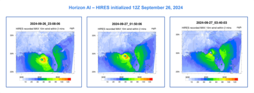
Short-Term, Local Forecast Enhancement: Horizon AI HIRES
While Horizon AI Global leads long-range tracking, Horizon AI HIRES sharpens the focus closer to landfall:
- Customizable down to 0.67 km resolution, offering hyper-local asset-level forecasting
- Advanced physics resolve fine-scale features like coastal convergence zones and topographic effects
- Forecasts out to 7 days, providing operationally critical updates as storms approach populated areas
Example: HIRES precisely captured Helene’s tightening wind field near Florida’s Big Bend coast — helping pinpoint local surge and rainfall risks.
Tips for Superior Hurricane Coverage
- Leverage both long-range and short-range models: Use Horizon AI Global for early detection and track planning, and Horizon AI HIRES for localized impact forecasting.
- Integrate multiple data sources: Cross-reference satellite, radar, aircraft, IoT, and other novel data for the clearest picture.
- Stay updated on emerging technologies: Real-time integration of novel data improves forecast reliability every year.
Improve Hurricane Prediction and Monitoring
Advanced hurricane tracking technologies are transforming safety, resilience, and operational preparedness. With tools like Horizon AI Global and Horizon AI HIRES, Climavision empowers governments, businesses, utilities, and communities to make informed decisions — not just days, but weeks ahead of landfall.
Better forecasts lead to faster response, minimized disruption, and saved lives. Contact Climavision to learn how our advanced models can strengthen your hurricane preparedness.


