Understanding QPE and Its Importance in Utility Planning
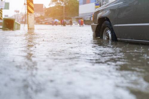
From localized flash flooding to widespread storm damage, precipitation is one of the most persistent and costly threats to utility infrastructure. Utilities across the country face mounting pressure to keep services running and infrastructure protected—despite increasingly volatile and unpredictable weather patterns. To stay ahead of the risk, organizations need more than just forecasts—they need real-time, high-resolution data that paints an accurate picture of what’s happening on the ground.
That’s where Quantitative Precipitation Estimation (QPE) comes in.
QPE provides critical rainfall insights that allow utility companies to plan more effectively, respond more quickly, and allocate resources more strategically. At Climavision, we’ve developed one of the most advanced radar-based QPE solutions on the market, leveraging cutting-edge radar science and our proprietary radar network to deliver hyper-local, real-time precipitation data when and where it matters most.
In Summary:
- QPE provides estimates of real-time and accumulated precipitation, critical for utility operations and planning.
- Climavision’s radar-based QPE combines national MRMS data with its proprietary radar network for enhanced accuracy and coverage.
- Multiple QPE time ranges—instantaneous to 24-hour—offer flexible, high-resolution insights updated as frequently as every 2 minutes.
- Radar-as-a-Service (RaaS) fills low-level radar coverage gaps, improving QPE reliability in underserved areas.
- Utilities can use QPE to improve flood awareness, outage response, and long-term infrastructure planning.
What Is Radar-Based QPE?
Quantitative Precipitation Estimation (QPE) is a data product that measures how much precipitation has fallen across a given region. Rather than relying on limited point observations like rain gauges, radar-based QPE uses radar variables such as reflectivity (Z), specific differential phase shift (KDP), and attenuation (A), to generate a hybrid algorithm to produce a broader, more comprehensive estimate of rainfall over large areas.
Climavision’s QPE system fuses traditional Multi-Radar Multi-Sensor (MRMS) data with our proprietary radar network to generate more complete and more accurate precipitation estimates—especially in areas that have historically lacked good low-level radar coverage.
The result? A detailed view of where, when, and how much rain has fallen, delivered with unmatched temporal and spatial precision.
Why QPE Matters
Precipitation is a major operational risk for utility companies—and one that can escalate quickly. QPE is important because it delivers timely, actionable information that traditional forecasts or ground sensors alone can’t provide. Here’s why it’s essential:
Improved Flood Awareness
Flooding doesn’t just depend on rainfall totals—it also depends on rainfall intensity, duration, and location. QPE helps utilities pinpoint areas experiencing heavy rain in real time, so they can monitor stormwater systems, pre-position response crews, and alert local stakeholders before flooding becomes critical.
Faster Outage Response
When infrastructure is saturated or storm conditions escalate quickly, the potential for power outages rises. QPE provides rapid updates on rainfall conditions, helping operations teams anticipate problems before they’re reported—leading to faster response times and better customer service.
Strategic Maintenance & Investment
By analyzing cumulative rainfall over time, utilities can identify patterns of high-risk zones, plan upgrades to aging infrastructure, and prioritize vegetation management or structural reinforcements in flood-prone areas.
Enhanced Emergency Coordination
During severe storms or extreme weather events, real-time QPE provides utilities a shared and reliable source of truth. That means better coordination across departments, clearer situational awareness, and stronger collaboration with emergency responders and government agencies.
The Technology Behind Climavision’s QPE
Climavision’s QPE is engineered to provide the most up-to-date and precise rainfall data available. Here’s how it works:
- 1 km x 1 km Grid Resolution: Captures localized rainfall variations that other systems may miss.
- Contiguous U.S. Mosaic: National coverage that allows for seamless monitoring of wide geographic areas.
- Rapid Update Cadence: Below are what Climavision produces currently for operations, however, any accumulation period can be produced to meet customer needs.
- Instantaneous QPE Mosaic – Updates with each new radar scan
- 15-Minute QPE Mosaic – Updated every 2 minutes
- 1-Hour QPE Mosaic – Updated every 2 minutes
- 24-Hour QPE Mosaic – Updated hourly on the hour
- Data Access: Available via API, Direct cloud integration (Azure / AWS), GIS Data Integration or LDM (Local Data Management) in GeoTiff or Netcdf formats.
- Units: Delivered in inches per hour (in/hr) for immediate operational use. However, this can be tailored to whatever units are needed.
This combination of resolution, speed, and flexibility allows utility operators to choose the QPE product that best fits their planning or response needs.
Enhancing Accuracy with RaaS: Radar-as-a-Service
One of the biggest challenges with traditional radar-based QPE is limited low-level radar coverage. Because the Earth is curved, measurements are less accurate as one travels further from the radar. That’s a major problem—especially in rural and mountainous areas where National Weather Service (NWS) radar coverage is sparse.
Climavision’s Radar-as-a-Service (RaaS) product solves this by deploying a proprietary network of low-level radar systems specifically designed to fill these coverage gaps. Over 130 million Americans currently live in areas with low-level radar blind spots. These same areas are often underserved by other forms of weather intelligence.
By supplementing the national radar infrastructure, our RaaS network ensures that QPE data is more complete and more representative of what’s happening on the ground—especially in areas where utility infrastructure is most vulnerable to sudden precipitation events.
Behind the software and algorithm development is a world-class team of radar scientists led by Dr. Micheal Simpson, whose previous role working with the MRMS group at the National Weather Center plays a key role in the performance of QPE and other radar-derived products. Together with partners and researchers, this team brings academic rigor and real-world expertise to every layer of the Climavision QPE solution.
How Utilities Use QPE in Practice
Climavision’s radar-based QPE can help utility companies across the country strengthen their weather resilience. Here are a few ways it can be used in day-to-day operations:
- Power Utilities: Monitor live rainfall rates to preemptively identify areas where saturated soils may lead to power line failures or substation threats.
- Water Utilities: Track 24-hour rain accumulations to detect stormwater runoff threats or potential combined sewer overflows.
- Grid Operators: Use 15-minute QPE mosaics during active weather to assess grid strain and prioritize outage restoration zones.
- Emergency Managers: Leverage real-time QPE data to coordinate cross-agency response strategies during high-impact storms.
The Bottom Line
In the utility industry, knowledge is power—and QPE is one of the most powerful tools you can use to stay informed, agile, and prepared.
By delivering detailed, accurate, and timely insights into rainfall intensity and accumulation, Climavision’s radar-based QPE empowers utilities to make smarter decisions and reduce risk before, during, and after precipitation events. And with our supplemental radar network enhancing the national system, we’re helping close dangerous data gaps and building a more resilient utility infrastructure for the future.
Ready to see how QPE can work for your team? Contact us to schedule a personalized demo or learn more about integrating Climavision’s radar-enhanced weather intelligence into your utility operations.


