Sizzling Summer of 2022 Highlights Need For More Accurate Weather Forecasting
The Summer of 2022 was one for the record books, but not in the way that one would hope. According to data from NASA, the previous year’s Meteorological Summer (June-August) tied the previous record set back in 2020, which was the hottest summer on record. This is impressive considering records data back to 1880. (NYTimes) On top of the worldwide record, numerous individual records were set internationally. Heathrow Airport recorded an all-time high temperature of 104 degrees, staggering considering England does not have widespread air conditioning.
A Changing Atmosphere Fuels Uncertainty
As advancements in technology and Numerical Weather Prediction (NWP) have increased over time, so has weather forecasting accuracy. (dw.com) However, our atmosphere has, and continues to, change over time, causing more erratic and severe weather. As the atmosphere becomes more volatile, forecast accuracy is more important than ever to see these incidents coming, and to prepare as much as possible. As we get ready for the 2023 summer season, with the potential for more record setting disasters and unexpected events, let’s see what we can learn by taking a look back at the summer of 2022.
Yellowstone Flooding
One event that stands out from the summer of 2022 is the devastating flooding that happened in Yellowstone National Park. A combination of rainfall rates well beyond what was forecasted alongside snow melt made for extremely dangerous conditions that many were not prepared for. As NPR puts it, “The Yellowstone National Park area’s weather forecast the morning of June 12 seemed fairly tame: warmer temperatures and rain showers would accelerate mountain snow melt and could produce ‘minor flooding.’” (NPR)
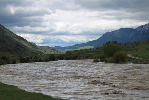
Yellowstone River flooding June 2022. Adobe Stock
0.8 to over 5 inches of rain fell from June 10 to June 13 through the Beartooth and Absaroka Mountain ranges, according to the National Weather Service in Billings. (CNN) This combined with five and a half inches of snow melt caused water to start rushing, leading to flooding rescues, and washed away homes and roads.
California Narrowly Avoids Blackouts
Besides inundating rains, other areas of the country saw drought and extreme heat. California saw late season extremes in September, with high temperatures in the triple digits for a long stretch of days. On September 6th, Sacramento, California hit 116 degrees, surpassing a record high set over 100 years prior. (CNBC) The city was not alone in the heat, as much of California was experiencing the same, as well as surrounding states.

A temperature sign at an El Dorado Savings Bank during a heatwave in Sacramento, California, on Tuesday, Sept. 6, 2022. David Paul Morris | Bloomberg | Getty Images
Because of the extreme heat, energy was in high demand to fuel air conditioning units. California Independent System Operator (CAISO) hit peak power demand at 52,061 megawatts. (Reuters) This put a lot of strain on the grid operator. States like Arizona and Nevada were also under pressure to meet power demand, taking away the option to look to neighbors to help share the load. Thankfully for CAISO, with the help of a well-timed emergency text urging customers to conserve power, they narrowly avoided rolling blackouts.
ERCOT is Pushed to Its Limits
Down in Texas, folks faced a similar story in July as the supply and demand lines almost met. The Electric Reliability Council of Texas (ERCOT) felt the strain on July 13th as a forecast for renewable energy supply did not pan out how they expected. However, more modern, up to date models like Climavision’s GRO model had accurately forecasted the unideal weather conditions.
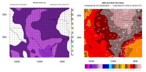
Figures 1 & 2: GRO consistently forecasted for 80m winds under 15 knots and triple digit heat since June 30th.
Be sure to view our case study on how a forecast missing lack of wind and extreme heat caused problems for the operator HERE.
Hurricane Ian
Hurricane Ian was a category 4 Atlantic hurricane whose track brought severe damage across western Cuba and in Florida and South Carolina in the United States. It was the deadliest hurricane for Florida since 1935and with 132 deaths the deadliest hurricane in the US since Hurricane Katrina. Beyond the devastating death toll, Ian also caused extreme damage to Southwest Florida. “Risk Management Solutions Inc., a Moody’s Analytics company, estimated insured losses from Hurricane Ian to be between $53 billion and $74 billion, with a best estimate of $67 billion,” (businessinsurance.com). This estimate includes wind, storm surge, and precipitation inland flooding. Risk Management Solutions estimates that the majority of total insured losses from the hurricane would be caused by wind and around 25% of the total insured losses resulting from storm surge and flood.
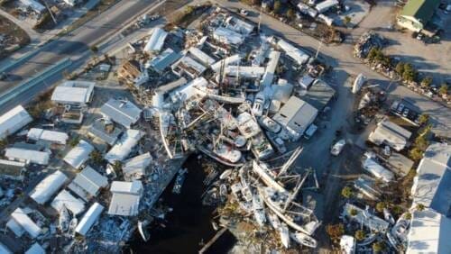
Fishing boats were pushed onto land by the historic storm surge from Hurricane Ian. 2022 Adobe Stock
The models evaluated for Hurricane Ian gave mixed signals on what path the storm would take — contributing to a surprise for many on the ground in Southwest Florida when Ian made landfall there. The models’ storm tracks were almost entirely too far to the northwest, though some were farther off than others. The GFS model was steadfastly predicting the hurricane landfall point well north of the storm’s actual track which caused the National Hurricane Center to be slow in adjusting its forecast southward in the days ahead of Ian. Even the European model, considered to be the most accurate forecaster of global weather patterns, skewed slightly northwest of Ian’s eventual track, gradually shifting its predictions toward the southeast as the storm approached. Eventually NHC did adjust the forecast south by more than 100 miles in the 30 hours before Ian made landfall.
What Can be Done about NWP Accuracy?
The problem with all these extreme events from Yellowstone to Hurricane Ian is forecasting models not keeping pace with the atmosphere as it becomes less predictable. Forecasting with a 30-year average mentality is outdated when areas like Yellowstone National Park have warmed 2.3 degrees Fahrenheit since 1950. (CNN)
The solution requires adapting to these New Norms in severe weather. This is not an easy task – it requires an entirely new approach. At Climavision we are revolutionizing this approach at several levels. First, we are increasing unique observational data from multiple sources like space-based data and other novel data set sources, giving more insight into what is happening even in remote areas in real time. The more data there is to input into weather models, the more accurate the model outputs will be generally. However, it cannot stop at just the observational data – the model itself needs to be optimized to accurately interpret the current observations to predict what will happen.
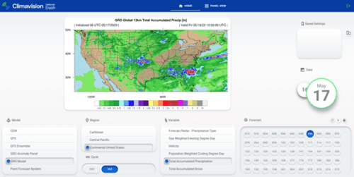
Climavision’s Dalton AI DASH Mapping User Interface Capturing GRO’s total Accumulated Precipitation Forecast for CONUS
Climavision’s Horizon AI Forecasting suite not only encompasses proprietary NWP models developed by Climavision’s experts in meteorology, they are powered by HPC computing and machine learning, allowing for increased processing speeds to deliver the fastest most accurate forecasts to businesses and communities. If you’d like to learn more about how this revolutionary insight may benefit your organization, contact us.

