2024: Tackling Severe Weather with Advanced Radar Coverage
Severe weather continues to be a growing challenge for the United States. According to NOAA (the National Oceanic and Atmospheric Administration), as of November 1, 2024, the country experienced 24 confirmed weather and climate disaster events, each causing losses exceeding $1 billion. These disasters—comprising 17 severe storm events, 4 tropical cyclones, 1 wildfire, and 2 winter storms—tragically resulted in 418 fatalities and left a significant economic toll on affected areas. To put this into perspective, the average number of such events annually between 1980 and 2023 was 8.5, while the most recent five years (2019–2023) have averaged a staggering 20.4 events per year.
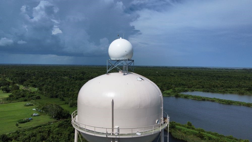
As these powerful and frequent weather events reshape the landscape of risk and resilience, mitigating their impact on public safety and businesses has never been more critical. For Climavision, 2024 was another year of significant progress. Building on the momentum from 2023, we further enhanced weather detection capabilities by expanding our supplemental radar network across the United States. These installations are instrumental in capturing low-level severe weather events that might otherwise go undetected, providing critical data to help safeguard lives, property, and infrastructure. Below are just some of the weather events from 2024 that highlight the power of high resolution, supplemental radar coverage.
In Summary
- Record-breaking Weather Events: In 2024, the U.S. experienced 24 billion-dollar weather disasters, underscoring the growing frequency and severity of extreme weather.
- Climavision’s Expanded Radar Network: Climavision installed supplemental radars across the U.S., improving detection of low-level severe weather events that might otherwise go unnoticed.
- Enhanced Severe Weather Insights: Case studies highlight Climavision’s ability to capture critical data, including tornado debris signatures, wind damage indicators, and outflow boundaries, providing life-saving insights.
- Filling Critical Observation Gaps: Climavision’s supplemental radar in Pennsylvania provided high-resolution data during record-breaking lake-effect snow, supporting more precise local reporting and public safety advisories.
- Driving Resilience Through Innovation: By delivering high-resolution radar imagery and filling gaps in coverage, Climavision empowers communities and businesses to better prepare for and mitigate the impacts of severe weather.
Hamilton, TX Wind Damage
On January 8th, damage was sustained by the Hamilton Municipal Airport in Hamilton, Texas. No warnings were issued, and the SPC did not receive any wind or tornado reports, but damage at the airport is evidence of a strong storm.
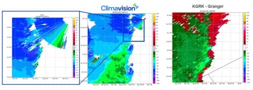
Climavision’s radar imagery (left) showcases wind speeds near 65 mph as the line of storms approached the airport. This can be seen by the values in purple on the popout image. KGRK shows lesser storm velocities that wouldn’t necessarily indicate wind speeds capable of damage, as well as the beginning of rotation on the leading edge of the storm.
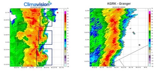
Climavision’s reflectivity indicates front reflectivity notches (highlighted w/ navy boxes). Working in conjunction with the radial velocity from Granger, one would be able to determine the beginning stages of rotation in these locations.
Kentucky/Indiana EF-2 Tornado
March 14th brought a severe weather outbreak over portions of the Midwest. While the CVG terminal Doppler radar was down, a tornado occurred across the Kentucky/Indiana border. The tornado was on the ground from Jefferson County, IN to Carroll County, KY. This powerful, EF-2 tornado was detected clearly by Climavision’s radar in Dry Ridge, KY and nearby NEXRADs. Climavision’s radar was also able to detect a debris signature.
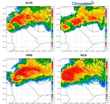
In the top right corner, Climavision’s radar shows an impressive hook echo signature. The nearest NEXRAD radars are also able to pick up on this signature through reflectivity. Notice the high definition of Climavision’s imagery, giving deeper insight into the rotation shown.
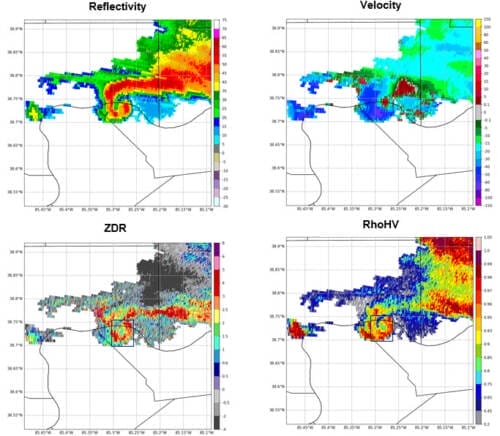
Above are all still images from Climavision’s radar at 1812Z, or 2:12 PM (EDT). Strong rotation is clearly seen in both the reflectivity and velocity data, showing a tornado is likely on the ground. RhoHV and ZDR can be used to identify a tornado debris signature (TDS). In this example, the lowering RhoHV and lowering ZDR together indicate TDS, helping confirm a tornado on the ground.
Mid-MO Outflow Boundary
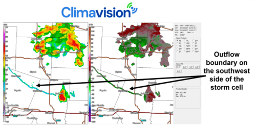
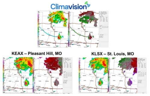
Several strong storms popped up around Climavision’s Boonville, MO radar on August 27th. The radar was able to clearly capture an outflow boundary coming off one of the cells. This is significant as outflow boundaries can impact aviation activity. Local ASOS stations identified wind speeds of 40 knots while Climavision detected winds in the range of 20-30 knots.
In comparison, neither KLSX or KEAX showed an outflow boundary in their data from the same timestamp.
Erie, PA Region Lake Effect Snow
Just after Thanksgiving, on Friday, November 29, 2024, a winter storm moved across the US. As the system crossed the Great Lakes, it dumped multiple feet of snow from Michigan and Ohio to western New York and the Erie region of Pennsylvania. Erie, PA set an all-time record with 22.6 inches of snow on Friday, and up to 42.5 inches by Sunday night. The event caused white out conditions and shut down major transportation corridors, such as I-90, on one of the busiest travel days of the year.
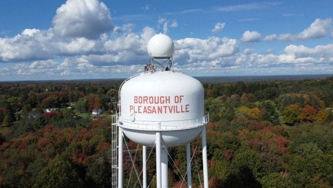
Climavision recently installed a supplemental radar in Pleasantville, PA to fill a low-level gap in observations in the Erie region. When compared to nearby National Weather Service radars (NEXRADs), the supplemental system captured heavier snowfall in certain areas. The high-resolution data captured on the supplemental system showed more clarity around impacted areas.
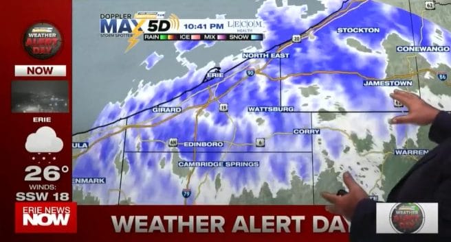
Image Courtesy of WICU
Climavision’s media client, WICU, (Erie News Now) showed the difference on air to assist in advising motorists and residents in the area. Meteorologist John Stehlin highlights the transformative impact of this improved radar coverage and its significance for Erie News Now viewers in the weather segment you can view here.
The Power of Enhanced Radar Coverage
The severe weather events of 2024 highlight the critical need for advanced forecasting and detection systems to protect lives, infrastructure, and businesses. Climavision’s supplemental radar network has demonstrated its ability to fill observation gaps and provide actionable insights in real-time, as shown in the case studies from Hamilton, TX, the Kentucky/Indiana tornado, Mid-Missouri, and Erie, PA.
These examples underscore how high-resolution radar data can make the difference in detecting and analyzing severe weather phenomena, from rotation and debris signatures to outflow boundaries and intense snowfall. By enhancing situational awareness and supporting timely decision-making, Climavision’s solutions empower communities and businesses to better prepare for and respond to severe weather.
As we look toward 2025, Climavision remains committed to advancing radar technology and expanding coverage to meet the challenges of an increasingly volatile climate. If your business or governmental agency is seeking to leverage data-driven insights to mitigate risks contact us today.


