Revolutionizing Weather Monitoring and Forecasting: Climavision’s Game-Changing National Supplemental Weather Radar Network and Forecasting Solutions
From Chris Goode, Founder and CEO of Climavision:
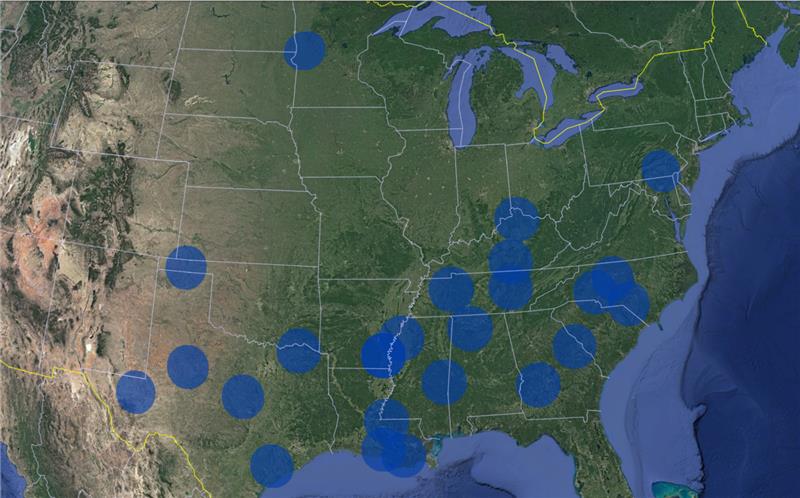
In the dynamic world of weather forecasting, precision is not just a goal; it’s a necessity. Climavision, a pioneer in weather technology, has embarked on a transformative initiative to deploy 200 gap-filling weather radars across the United States over the next 3-4 years. At the close of 2023 the network stands at 24 radars providing vital low-level weather detection in areas that previously lacked comprehensive coverage. This ambitious project is poised to reshape weather monitoring in the United States and unlock a myriad of benefits for partners and stakeholders in government and several weather sensitive industries.

Pictured above: Climavision proprietary network of 24 high resolution X-band radars at the close of 2023
Climavision’s Strategic Deployment:
The Weather Act Reauthorization passed the House in the fall and is currently before the Senate. It strengthens and advances the legislative goals of the 2017 Act. One of those 2017 provisions (Sec. 414) required that the Department of Commerce complete a study on gaps in the coverage of the NWS’s Next Generation Weather Radar. That Act also required that Commerce submit recommendations to Congress for improving hazardous weather detection and forecasting coverage in areas of the United States where limited or no Next Generation Weather Radar coverage has resulted in insufficient warnings or degraded forecasts for hazardous weather events. Climavision paid close attention to that section, and it was a major impetus behind the establishment of our nationwide commercial radar network that will provide coverage for those communities that reside in areas that historically have been referred to as radar data gaps.
Because extreme weather events are happening more often than ever before, lower-level atmospheric radar surveillance is critical to meteorologists and imperative for severe weather detection, forecasts, and warnings. While the United States has one of the most prominent radar networks in the world, there are still low-level gaps the network doesn’t cover completely, putting areas at risk for missed warnings and vital weather updates. The bill builds upon the Weather Act by expanding NOAA’s authority to contract with the private sector to acquire commercial weather data. It also establishes a pilot program for data providers to test their data with NOAA and for NOAA to validate such data when incorporated into their models and forecasts.
Since early 2022, Climavision has been cooperating with NOAA’s National Severe Storms Laboratory (NSSL). As of September this year, Climavision entered into a strategic contract with the National Mesonet Program to deliver radar data to NOAA and National Weather Service (NWS) forecast offices in the eastern and southern regions. The data collected by Climavision’s radars is channeled to these offices, enriching their forecasting capabilities, and providing a more comprehensive understanding of weather conditions. This collaborative effort aims to enhance the accuracy of public weather alerts and improve overall community safety.
Climavision’s network is now live in storm-prone states such as Oklahoma, Texas, Louisiana, Georgia, North Carolina, Mississippi, Arkansas, Kentucky, and Tennessee, with more radars coming online every month. Climavision’s data is an especially important contribution to the NMP because our radars are specifically designed to provide low altitude coverage in areas located between NWS NEXRAD radars. NEXRAD is the cornerstone of real-time weather monitoring, but the distance between its sites still leaves some parts of the country without radar coverage nearest to the ground – exactly where damaging weather can form quickly. Climavision’s radars sit directly in these “low level radar data void areas” and provide high-resolution surveillance that increases NWS knowledge of weather conditions.

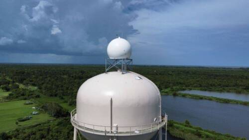
Pictured above: Climavision’s radar installation in Chauvin, LA
Importance of High-Resolution Forecast Models:
While our supplemental radar network offers vital real-time information, the full value is unlocked when this data is assimilated into high-resolution forecast models. Climavision’s commitment goes beyond merely filling gaps; it extends to harnessing the full potential of the data collected. High-resolution forecast models are pivotal in providing more accurate forecasts, particularly in rapidly developing weather situations where precision is of the essence.
Benefits to Various Sectors:
Climavision’s radar network deployment and forecasting solutions yield a multitude of benefits across different sectors, each playing a crucial role in improving decision-making and enhancing safety.
Television Media:
Meteorologists and broadcasters in the television media sector now have access to a wealth of real-time and high-quality data. Our radar data empowers them to deliver more accurate and timely weather forecasts to the public. This not only enhances the credibility of media outlets but also ensures that viewers receive information crucial for making informed decisions during severe weather events.
Energy Markets:
The energy sector, with its sensitivity to weather conditions, stands to gain significantly from Climavision’s radar deployment and predictive modeling. Accurate and timely weather data enables energy market participants to optimize their operations, manage risks effectively, and ensure the reliability of energy infrastructure. This, in turn, contributes to the overall resilience of the energy market.
Transportation:
In the transportation sector, where weather plays a critical role in safety and efficiency, Climavision’s radar data and forecasts are a game-changer. Airlines, shipping companies, and ground transportation services can make more informed decisions regarding routes, schedules, and safety measures. This not only improves operational efficiency but also enhances overall safety standards.
Government Agencies:
Climavision’s collaboration with government agencies at all levels is instrumental in bolstering disaster preparedness and response. The high-resolution data from the deployed radars facilitates more accurate decision-making for emergency management and disaster relief efforts. Government agencies can proactively implement measures to mitigate the impact of extreme weather events on communities.
Case Studies Highlighting Value:
Over the past several months, Climavision has dedicated efforts to developing case studies that vividly illustrate the value of gap-filling radars supplementing the government-provisioned NEXRAD network. These case studies serve as compelling evidence of the positive impact Climavision’s radar deployment has on various sectors, showcasing real-world scenarios where accurate and timely weather data proved to be a game-changer.
Conclusion:
Climavision’s initial deployment of 24 gap-filling weather radars in the southeastern United States is a testament to its commitment to advancing weather monitoring and forecasting. The collaboration with the National Mesonet Program, NOAA, and NWS forecast offices reflects a dedication to improving the safety and well-being of communities. As we look ahead, the transformative impact of Climavision’s national supplemental radar network is set to resonate across industries, shaping a future where accurate and timely weather information is not just a luxury but a fundamental necessity for a resilient society.
About Chris Goode:

Chris Goode is a strategic growth expert, hands-on leader, and tech start-up founder. For almost 30 years, Chris has pioneered merging big data, meteorology, and remote sensing – a lifelong passion that has now culminated in the launch of Climavision – a gamechanger for weather and climate technology. He founded Climavision to expand access for all communities to have valuable weather radar coverage. Through strategic partnerships and decisive investments, his team is alleviating government agencies from the burden of expensive weather infrastructure and rolling out a proprietary network of ground based Radar-as-a-Service weather radars that will end low level radar data void areas that will help warn communities of severe weather.


