Millersville University Student Compares Precipitation Estimates Using X-band Radar
A 2025 graduate of Millersville University’s Meteorology Program, Alexander Sullivan, utilized data from Climavision’s Millersville weather radar to analyze the benefit of gap-filling weather radars and various methods of calculating quantitative precipitation estimates (QPEs). Through his research project he identified the best method for calculating QPE depending on the type of weather in the area, where one equation worked best for a cold-season storm and another more accurately depicted a warm-season event. He hopes his research experience will help as he starts his career in operational meteorology.

Introduction
Alexander Sullivan, a 2025 graduate of Millersville University’s Meteorology program, analyzed different methods of calculating quantitative precipitation estimate (QPE) for his honors thesis. His goal is to inform other meteorologists, researchers, and radar network operators, among others, on the most effective way to estimate precipitation.
What is QPE? QPE, or quantitative precipitation estimate, is the amount of rainfall in a given area over a given time period. This is a derived radar product, meaning it is calculated through an algorithm based on raw radar data. Essentially, QPE estimates rainfall intensity over a certain area to provide valuable insight on flooding threats and watershed maintenance. This product has many important forecasting and hydrological applications for public safety and maintenance officials alike.
Background
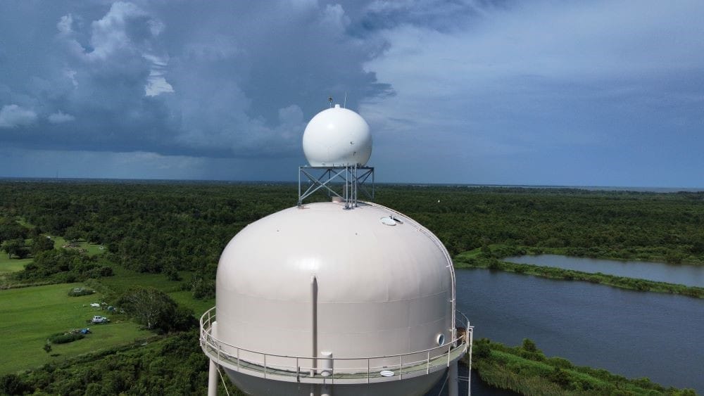
In the summer of 2023, Climavision partnered with Millersville University to install an X-band weather radar on the University’s water tower and offered radar access for campus and community safety, teaching and learning, and research purposes. Prior to the installation of the new X-band system, Millersville, Pennsylvania and surrounding areas were in what is known as a “weather radar gap.” A weather radar gap is where the existing National Weather Service (NWS) radar is not able to effectively detect weather below 4,000ft above ground level. This means there is no efficient way to detect weather threats in a radar gap without a storm spotter putting themselves in danger of potentially severe weather. Due to their position in the gap area, this area could not discern specific events that were not detected by the NWS radars. The new technology provides valued through added information to meteorologists for more timely and accurate forecasts for the community.
Alexander learned about the Climavision radar and the associated date in more detail while taking a class on radar meteorology. He was curious about the value it provided and wanted to analyze the radar data and its benefit to QPE analysis given the value of QPE products and the NWS’s use of such products to issue flash flood warnings and flood guidance. Furthermore, it helps local officials with storm water management, operational decisions, and drought monitoring. For public safety, QPE can offer warnings or insight into flash flooding for severe weather events or areal flooding over longer precipitation events.
The Research Project
Alexander’s project focused on multiple methods of calculating QPE and determining which QPE calculation method is most effective depending on event type and how effectively X-band radar can be used to create QPE data. The three algorithms he evaluated were the Marshall-Palmer Z-R relation, a standard attenuation-based algorithm, and an improved attenuation-based method that accounts for temperature and wavelength, which impact how a weather radar’s signal functions. He analyzed these three algorithms for two different weather systems, one from a warm season and one from a cold season, and compared them with values measured by a standard rain gauge.
Ultimately, he determined that different methods worked best depending on the types of precipitation events. For example, he identified that attenuation-based methods performed best during warm-season storms with heavy rain, while the Marshall-Palmer Z-R relationship performed best in cold season precipitation events where attenuation is weaker. The reason for this boils down to how a weather radar works and what values each QPE equation favors. The Marshall-Palmer Z-R relationship relies on reflectivity data to estimate rainfall rates. As a result, this equation does not perform well if there is signal loss or attenuation. Attenuation occurs when precipitation scatters or absorbs the radar beam which can occur during strong, summer-season events. In general, the attenuation-based methods are better suited for QPE calculations since they are less sensitive to the variability of raindrop size distributions than conventional radar rainfall estimators.
Weather radar-based rainfall estimation continues to be an active area of research. While radar-based techniques are well accepted and incorporated into practice, many parts of the country and the world do not have adequate weather radar coverage. Gap-filling radars, such as those being deployed by Climavision across the United States help to provide this critical information.
This project was no easy task. Alexander worked with large volumes of data and was limited by time. He had to prioritize specific variables and methods and was supported in his efforts through Climavision’s radar science and operations team that answered his questions and provided guidance on radar data analysis techniques. When asked what he enjoyed about this project, he shared, “I really enjoyed learning how to work with radar data and seeing how it applies to real-world problems. Exploring different rainfall estimation methods showed me how versatile radar can be, not just for storm tracking, but for quantitative analysis and decision-making. It was rewarding to see how the data I processed could translate into meaningful insights for weather forecasting and hydrology.”
Going forward
One of Alexander’s professors and advisors was instrumental in getting the Climavision radar installed on campus and in starting the academic partnership with the company. Dr. Sepi Yalda, a long-standing faculty member in the Meteorology Program and the primary instructor for the Radar Meteorology course, has seen the benefits from the gap filling radars. She says it has been highly impactful in the activities of the Millersville University’s Campus Weather Service. In the classroom, she shared that Climavision radar access has been invaluable for students as it grants the opportunity for hands-on learning and research of local weather events in a way they were not able to do previously. This radar has sparked additional student research projects on the applications of these gap-filling radars. Another Millersville University student conducted an honors research project with the Climavision radar and focused, “on the importance of gap filling radars through two specific case studies and surveys of meteorologists and emergency managers which highlighted the applications in predictions and decision support.”
What’s next for Alexander? Now that he has graduated, he plans to pursue a career in operational meteorology, focusing on real-time decision-making and communication through impact-driven forecasting.
Climavision’s Dedication
Climavision is dedicated to enhancing public safety and research efforts through the use of gap-filling weather radars. The company partners closely with academic institutions on classroom opportunities and workforce development. If you are interested in establishing an academic or research partnership, please reach out to us.


