Climavision’s HIRES and Radar Network Tracked Kentucky’s Deadly May 16 Storms
On May 16, 2025, a powerful line of severe storms swept across Kentucky, bringing with it large hail, destructive winds, and multiple tornadoes—including a long-track, EF-3 tornado that caused widespread damage and tragic loss of life. As the supercell moved across southern Kentucky, the need for precise, early, and hyperlocal weather intelligence became more urgent than ever.
Climavision was uniquely positioned to help. Our Horizon AI HIRES model identified the threat 48+ hours in advance, well before most models began to agree. And as the storm took shape, our Radar-as-a-Service (RaaS) system—including the KY91 radar in Jamestown, KY—delivered real-time, low-level detection of dangerous tornado activity, often minutes before traditional radar systems.
This one-two punch of long-range high-resolution forecasting and supplemental radar monitoring gave forecasters and emergency managers a vital edge.

In Summary:
- Horizon AI HIRES provided a 48-hour lead time on the May 16 Kentucky tornado outbreak—well before other high-resolution models showed the threat.
- Climavision’s KY91 radar in Jamestown detected tornado debris signatures (TDS) 13 minutes earlier than nearby NEXRAD radar, thanks to lower beam heights and higher resolution.
- Together, HIRES and KY91 bridged the gap between forecasting and real-time monitoring, offering early confidence and precise, low-level storm visibility.
- Broadcast meteorologists, emergency managers, and utilities benefit from more accurate tornado placement, earlier warnings, and better situational awareness.
- Climavision’s integrated forecasting and radar network helps decision-makers act faster, reduce uncertainty, and protect lives and assets during high-impact weather events.
Forecasting the Threat Early with Horizon AI HIRES
Climavision’s Horizon AI HIRES model is a next-generation, high-resolution weather prediction model designed to provide early, precise, and location-specific forecasts—even beyond the short-range limitations of other high-resolution tools.
On the morning of May 14, HIRES was already highlighting the potential for a damaging line of storms with tornadoes embedded to move through Kentucky during the evening of May 16. At this 60+ hour range, forecasters typically rely on coarse, lower-resolution global models that may not capture the nuanced risk of rotating storms.
But HIRES is different. With 2 km resolution and AI-powered insights layered on top of numerical weather prediction (NWP), HIRES offered granular detail well before other high-res models even became available.
In this case, the signal from HIRES provided increased confidence—allowing earlier planning and preparation. By comparison, widely used high-resolution models like HRRR didn’t align with the risk until the day of the event.
That extra 48-hour lead time is more than just a luxury—it’s often the difference between proactive preparation and last-minute reaction.

Seeing the Storm Clearly with KY91 Supplemental Radar
While forecasting helps you anticipate risk, real-time radar is what confirms it. On May 16, as storms moved across Kentucky, Climavision’s KY91 radar—part of our proprietary Radar-as-a-Service network—proved critical in tracking and validating the most dangerous parts of the system.
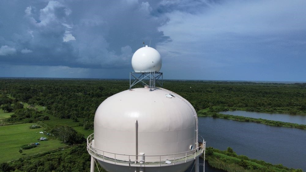
Located in Jamestown, KY, KY91 is a gap-filling radar that provides high-resolution coverage where the national radar network (NEXRAD) has limited low-level visibility. In fact, the nearest NEXRAD system (KLVX) is approximately 86 miles away, meaning it often scans storms from a much higher altitude.
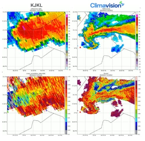
As a powerful supercell tracked across southern Kentucky, KY91 captured a Tornado Debris Signature (TDS) over Somerset a full 13 minutes before the KJKL NEXRAD site. The difference? KY91’s lower beam height (just 350 meters AGL) and higher spatial resolution enabled it to detect debris and rotation closer to the ground, while KJKL’s beam was positioned over 2,400 meters above ground level—missing the critical early signals.
KY91 also showed a more defined reflectivity hook and pinpoint debris ball, enabling meteorologists to confirm not just that a tornado was occurring, but exactly where and when.

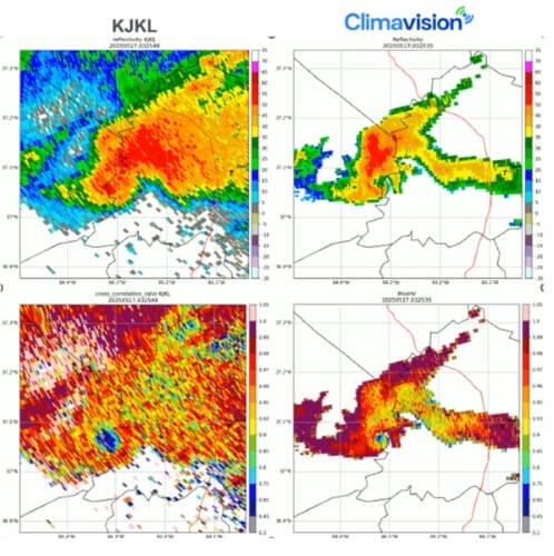
Farther east in London, KY, the tornado continued to track. This time, both KY91 and KJKL captured the event with strong signatures, but again KY91 offered greater clarity early on, before the storm moved closer to KJKL’s range. This complementary radar overlap validated the storm’s structure and track—ensuring warnings stayed accurate and timely.

From Forecast to Nowcast: A Seamless Weather Intelligence Pipeline
What makes Climavision truly unique is our ability to connect early forecasting with real-time validation. Most providers offer either model guidance or observational tools—but not both in a seamless, proprietary ecosystem.
On May 16, this made a measurable difference:
- HIRES gave meteorologists an early, high-resolution view into a potentially volatile setup days before traditional high-res models weighed in.
- RaaS filled the radar gaps, especially in terrain-challenged or underserved regions like central and southern Kentucky, providing critical visibility into the lowest parts of the atmosphere—where tornadoes are born and do the most damage.
This integrated approach helps broadcasters, emergency managers, and public safety officials act faster, communicate more confidently, and ultimately save lives.
The Broader Implications for Weather-Driven Industries
While this event underscores the life-saving potential of accurate weather tools for public safety, it also highlights the value for multiple industries:
- Emergency Management: More accurate and earlier tornado detection improves public alerting and response times.
- Broadcast Media: Access to hyperlocal radar and extended high-resolution forecasts supports better storytelling and viewer trust.
- Electric Utilities: Early storm prediction and detection reduce asset damage, downtime, and customer disruptions.
- Transportation & Logistics: Precise storm tracking helps reroute operations, minimize delays, and enhance safety.
For these sectors and more, the combination of Climavision’s AI-driven forecasting and radar intelligence offers operational clarity where it matters most.
When Minutes and Miles Matter, Precision Wins
The May 16 tornado outbreak in Kentucky was tragic—but it also demonstrated the future of weather technology in action. Climavision’s Horizon AI HIRES and Radar-as-a-Service systems delivered a clearer, earlier, and more localized view of the threat—helping communities stay ahead of the storm.
As extreme weather becomes more frequent and volatile, decision-makers need tools that can close the gap between “what might happen” and “what is happening right now.”
With Climavision, that gap is closing.
Want to learn more? Reach out to schedule a demo or discover how our solutions can support your mission—whether you’re in forecasting, emergency response, media, utilities, or beyond.


