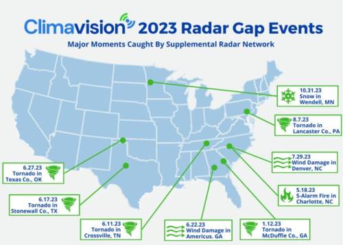
2023 Radar as a Service Recap
2023 was a year marked by severe weather. According to NOAA (the National Oceanic and Atmospheric Administration), the United States experienced a record-setting 25 weather/climate disasters with losses exceeding $1 billion each (as of December 8). As such powerful and devastating weather events become more common, mitigation of impacts on the public and businesses alike gains increasing importance. With that in mind, 2023 was a year of important milestones for Climavision too. We installed 18 new supplemental radars across the United States that captured low level severe weather events that may have otherwise gone undetected.
Harlem, GA Tornado
Climavision’s year got off to a dramatic start in January. The recently installed Harlem, Georgia radar, detected a tornadic signature only moments after the data came online. On January 12th, a funnel cloud was reported in McDuffie County at the Thomson McDuffie County Airport. Climavision’s radar was able to detect the tornadic signature clearly and accurately as the storm cell moved from near the airport, towards the Georgia-South Carolina border. The funnel cloud was reported at 4:45 PM EST, minutes after the signature showed up on Climavision radar. At 5:00 PM EST, a Tornado Warning was issued by the KCAE forecast office in Columbia, South Carolina.
This is a prime scenario to showcase how supplemental radars boast big benefits for municipalities outside the range of clear, low-level coverage from larger cities. As the tornado continued into South Carolina, the NEXRAD radar at the Columbia, SC forecast office was able to clearly see and continue tracking the storm. Upon assessment by National Weather Service teams, the tornado was later rated an EF-1.

Crossville, TN Tornado
Another core radar data example occurred in Crossville, Tennessee. WATE-TV viewers spotted the unwarned tornado on June 11th. In the imagery below, it is clear as to why the tornado went unwarned, given nearest NEXRAD radars (6,200 ft and 7500 ft AGL heights of the KOHX and KMRX radar sweeps, respectively) did not have a detailed view of the storm and tornadic signature.
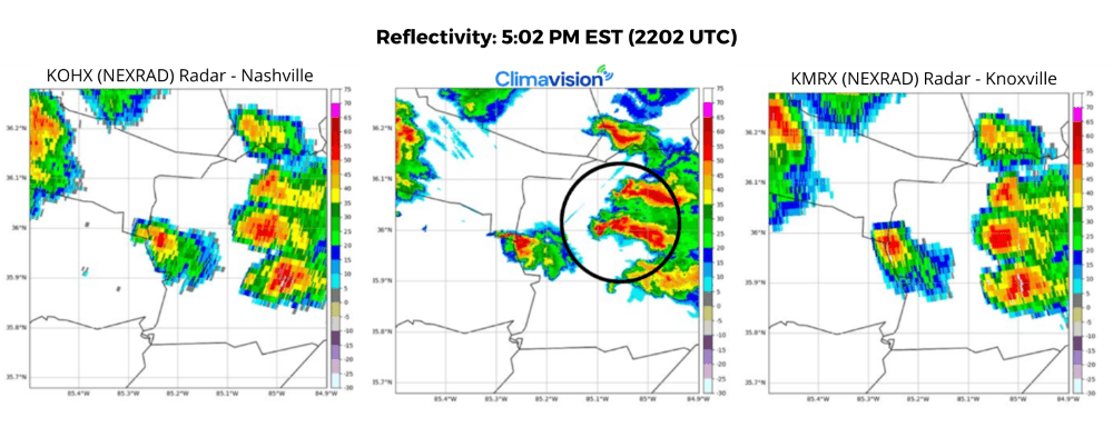

The June 11th EF-1 tornado event, alongside the Harlem, Georgia tornado, gives clear evidence of the lifesaving information that Climavision’s supplemental radar network supplies. Low-level coverage between existing NEXRAD sites provides clarity and critical radar coverage for areas that need it the most. Thankfully, no one was harmed during either event.
QPE (Quantitative Precipitation Estimation):
Tornadoes commonly come to one’s mind when considering the devastating impacts severe weather can bring, but rain and related flooding can be just as dangerous. Knowing just how much rain is falling in a particular domain can help municipalities alert to flooding concerns and get a head start on road closures to prevent flood waters from sweeping vehicles off roadways.
Climavision’s radar in Edna, Texas covers a portion of the state’s Gulf Coast. As tropical storms, hurricanes, and even run-of-the-mill thunderstorms impact the area, it is important to understand how much rain is falling and the ripple effect at hand.

In the images above, the blue circles represent overestimated precipitation whereas red represents underestimated precipitation. The radar data from KHGX, KCRP, and KEWX all strongly overestimate the ground truth rainfall, with KHGX showing a discontinuity in data due to distance from the radar site. While Climavision’s QPE showed one underestimated data point, overall, the data was significantly more aligned with the ground truth from remote sensing stations.
Wind
Wind events can bring significant damage, and when wind speeds surpass the 58mph severe storm threshold, it is important to alert the public so safety precautions can be taken. One such event occurred on July 29th near the Charlotte, North Carolina metro area – a well-known radar gap that existed for many years. In the image below, a strong line of storms is moving in a southeastward direction towards Charlotte. The Climavision radar data provides a more concise view of where the strongest portions of the storm are concentrated.


Snow
Climavision’s year wrapped up as winter-like weather began, and was captured on the newly installed Wendell, Minnesota radar. On October 31st, Climavision radar captured a snow event that the nearest NEXRAD radars overshot. The Northern Plains has more sparse low-level data coverage than more populated areas of the United States, making supplemental radar data a great benefit to the area. In the following radar images, Climavision’s Wendell radar performs with great accuracy and resolution, giving emergency management and city officials a clear view of the event at hand, and allowing for adequate response.


Conclusion
One of the most important highlights of 2023, aside from pulling critical radar data, is Climavision’s partnership with the National Mesonet Program. Through this partnership, the National Weather Service now has access to Climavision’s radar data and can evaluate its use and the important information it can provide in their daily and severe weather operations. As Climavision’s supplemental radar network continues to expand in 2024, more lifesaving radar coverage will benefit millions of Americans. If you’d like to learn more about Climavision’s radar network and how it can benefit your organization or community, contact us.


