How DOTs Can Improve Winter Operations With Combined Radar + High-Resolution Forecasting
Winter operations teams in transportation offices know that lake-effect snow is among the most demanding weather scenarios to manage. These events form quickly, intensify without warning, and shift unpredictably, creating hyper-localized hazards that vary dramatically from one community to the next. Traditional tools such as distant radar sites, coarse global models, and broad-stroke forecasts often leave Departments of Transportation (DOTs) with blind spots at the exact time they need precision the most.
An early November 2025 lake-effect snow event that impacted the Erie region of northwest Pennsylvania, southwest New York, and northeast Ohio provided a clear demonstration of where traditional solutions fall short—and highlighted the potential impacts when transportation agencies have access to both accurate long-lead, high-resolution forecasts and low-altitude, gap-filling radar coverage. It also exposed a crucial reality: planning gaps are caused by incomplete data.
Climavision’s Horizon AI HI-RES model and supplemental radar network each brought unique strengths to this event. When combined, they delivered a level of situational awareness that fundamentally enhances how DOTs and winter maintenance teams prepare, respond, and keep drivers safe.

In Summary
- Climavision’s Horizon AI HI-RES model correctly identified narrow, high-impact lake-effect snow bands nearly a week in advance, showing the type of early insight DOTs could leverage for pretreatment, staffing, and resource planning. This level of insight and lead time was not available through traditional, public weather data models and forecasts.
- Climavision’s supplemental PA109 radar captured low-level snow bands that distant, publicly owned and operated National Weather Service (NWS) NEXRAD sites completely overshot, illustrating the real-time visibility DOTs need during rapidly developing events such as the November 2025 storm.
- Together, Climavision’s HI-RES model and supplemental radar provide a complete operational picture—long-lead forecasts plus real-time ground truth—demonstrating how DOTs can anticipate and respond to fast-changing winter hazards more effectively.
- The combined data set highlights clear opportunities for DOT storm response. Better accuracy and longer lead times allow for optimized, strategic planning to include more efficient plow routing, targeted roadway treatment, signage positioning, and improved driver safety.
A Fast-Moving, High-Impact Early Season Event
Between November 11–12, 2025, a powerful cold snap pushed across the Midwest and Northeast. Snow bands developed rapidly off the Great Lakes, reaching as far south as northern Georgia, a rare occurrence for early November. The Erie, PA region experienced the heaviest, most persistent snowfall:
- 10–12 inches of accumulation
- Multiple rounds of snow squalls
- Rapid changes in visibility and roadway conditions
- Terrain-driven band behavior that shifted mile by mile
This event showcased exactly why lake-effect snow is so challenging for transportation: conditions change quickly, impacts vary between roads and across short distances, and timing of band development or dissipation can dramatically impact safety and operations.
In situations like this, transportation and public safety officials would typically rely on public data, which is often inaccurate and not timely enough for dynamic storm events because of limited infrastructure and modeling flexibility. Without enough lead time to prepare and accurate, real-time situational awareness, agencies are often left reacting instead of anticipating. This case study, which analyzes what Climavision’s modeling and real-time radar data showed compared to the available traditional public data, demonstrated how supplemental data – both high-resolution modeling and real-time, high-resolution weather radar – can provide better, more timely and accurate insights that dramatically improve outcomes and save time and resources during winter weather.
How HI-RES Gave DOTs Days of Advanced Insight
Unlike most high-resolution models, to include the public models we’re used to such as the HRRR, which typically extends 18 hours and up to 48 hours in some cases, Climavision’s Horizon AI HI-RES model provided accurate signals nearly a week in advance of the storm.
On November 4, 7 days out from the event, HI-RES showed:
- The likely placement of high-intensity lake-effect bands
- A narrow corridor at risk for 12+ inches of wet snow
- Early indicators of how terrain interactions could enhance band development
- A more accurate picture of the snowband orientation than any other model
By contrast:
- Longer outlook publicly available global models, such as the GFS and ECMWF highlighted general snowfall potential, but smoothed over fine-scale features that can DOTs could use for more localized, proactive planning.
- The coarser grids of the public global models blurred the most operationally important outcomes, such as narrow, road-specific hazards and intense short-duration bursts.
Operationally, this early insight means DOTs can:
- Begin scheduling crews and coordinating contractors days earlier
- Pre-position plows, salt trucks, and brine applicators in the correct corridors
- Adjust treatment plans based on expected snow intensity, not general snowfall guidance
- Pre-deploy road signage
- Communicate upcoming risks to state partners, emergency responders, and the public
- Strategically allocate limited resources before the first flake falls
Traditionally, lake-effect snow events rarely come with this level of resolution or early warning, but supplemental data through high-resolution modeling and gap-filling weather radar now make this possible – and finally provide a resource for more strategic, cost-effective winter weather planning.
How Climavision Radar Captured the Real-Time Truth
In addition to advanced insights that come from high-resolution modeling, gap-filling weather radar, such as Climavision’s system located in Pleasantville, PA, provided an entirely different level of operational visibility than the nearest NWS NEXRAD, located nearly 90 miles away. Because this system overshot the low-level snow bands forming off of Lake Erie, it missed several inches of impactful snow, resulting in an incomplete and sometimes misleading picture.
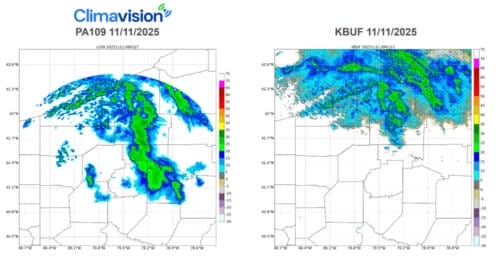
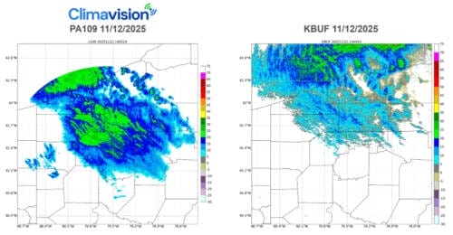
The gap-filling, supplemental radar filled the data void by capturing the true, ground-level structure of the storm.
Radar advantages for winter operations include:
- Low-altitude scanning that sees beneath NEXRAD beam height
- Real-time identification of snowband intensity and shape
- Accurate tracking of band drift to anticipate corridor impacts
- The ability to monitor sudden transitions into whiteout conditions
- Improved routing decisions for plow fleets and emergency services
- More timely scans of the atmosphere ensuring real-time visibility into dynamic changes.
Lake-effect snow often forms and intensifies below 3,000 feet, outside of the range of distant radars. This makes supplemental radar not just helpful, but a must-have for real-time decision-making.
The Real Power: Combining HIRES + Radar
On their own, radar and modeling can offer substantial operational benefits, but together, this supplemental weather data combination provides the longest-range planning and preparation window and the best possible view of real-time situational awareness.
HI-RES + Radar provides DOTs with:
- Earlier and more precise preparation
HI-RES identifies likely high-impact corridors nearly a week out, enabling proactive decisions instead of last-minute scrambling.
- Real-time verification and updates
Radar confirms exactly where bands form, how they evolve, and when conditions change along specific routes.
- Optimized resource deployment
DOTs can split, reroute, or consolidate fleets based on live radar feeds —avoiding wasted treatment or unnecessary overtime.
- Clear communication and improved safety
Accurate, consistent data helps agencies coordinate with law enforcement, emergency responders, public transit, and motorists.
- A unified operational picture from start to finish
Together, HI-RES and radar answer all three critical questions DOTs ask during winter storms:
- What’s coming?
- Where will it hit?
- What’s happening right now?
Integrated visibility is what transforms winter weather operations from reactive to proactive.
What DOTs Could Achieve With Combined Data
During this storm, DOTs leveraging both HIRES and radar insights could:
- Build confidence around likely impacts and vulnerable areas
- Begin pretreatment earlier and selectively
- Direct plows to the most at-risk roadways based on HI-RES forecasts
- Use radar to monitor changing hazards minute by minute
- Adjust deployment in real time rather than relying on outdated expectations
- Enhance situational awareness for dispatchers and field teams
- Reduce unnecessary treatment of unaffected stretches of highway
- Improve safety for both motorists and operators during squalls
- Strengthen communications with emergency managers and other agencies
This is a tangible, measurable improvement in operational readiness and roadway safety.
To learn more about how these combine insights can specifically help your operations, contact us.


